

A Tornado Watch has been issued for northeast Wisconsin through 11 p.m. Monday. Strong tornadoes, 75 mph winds and large hail are all possible.
3 Things to Know
- Tornado Watch until 11 p.m.: Conditions favor several tornadoes, including the possibility of a few strong (EF2+) tornadoes.
- Destructive winds possible: Storms may produce wind gusts up to 75 mph along with hail as large as 2.5 inches.
- Be ready to act: Watches can quickly become warnings. Have multiple ways to receive alerts and know where you’ll take shelter if warnings are issued.
A dangerous severe weather setup is unfolding across northeast Wisconsin this afternoon and evening.
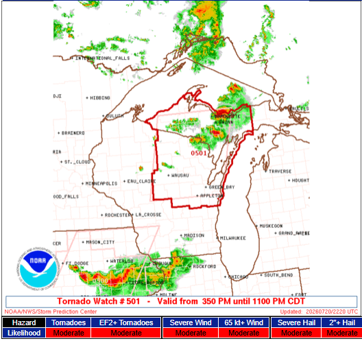
The Storm Prediction Center has issued a Tornado Watch for much of northeast Wisconsin and the Upper Peninsula of Michigan until 11 p.m. CDT Monday. Forecasters say conditions are favorable for the development of powerful supercell thunderstorms capable of producing tornadoes, destructive winds and very large hail.
Unlike a warning, a watch means the atmosphere is primed for severe weather. Now is the time to review your safety plan and be prepared to act quickly if warnings are issued.
Areas Included in the Tornado Watch
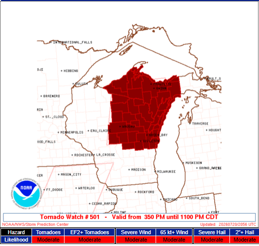
The watch covers much of northeast Wisconsin, including the Green Bay area, along with the Upper Peninsula of Michigan. Portions of Lake Michigan and Lake Superior are also included.
The Biggest Threats
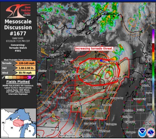
Forecasters say the environment is supportive of several dangerous hazards:
- A few tornadoes are likely, including the potential for a couple of strong (EF2+) tornadoes
- Damaging straight-line winds are likely, with isolated gusts up to 75 mph
- Large hail is expected, with isolated stones reaching 2 to 2.5 inches in diameter
Storms are expected to develop as discrete supercells late this afternoon before gradually clustering together during the evening. As that transition occurs, the threat for widespread damaging winds will increase.
Timing
The watch is in effect until 11 p.m. CDT.
The greatest tornado threat is expected during the late afternoon through the evening, with damaging winds becoming a larger concern later tonight as storms organize into clusters.
What You Should Do Now
If you live within the watch area:
- Make sure you have multiple ways to receive weather warnings.
- Identify the safest place in your home, preferably a basement or an interior room on the lowest floor.
- Be prepared to move immediately if a Tornado Warning is issued.
- Secure outdoor furniture and avoid unnecessary travel as storms approach.
You can track the watches and warnings on our Live Stream any time.
Bottom Line
This is not a routine summer thunderstorm setup. The Storm Prediction Center is highlighting the potential for strong tornadoes, destructive wind gusts up to 75 mph and very large hail across northeast Wisconsin this evening. Stay weather aware, keep your phone charged and have a reliable way to receive warnings as storms develop.
