
Warm and breezy start to the week across Wisconsin followed by gusty winds, scattered storms, and a midweek cooldown with frost risk returning.
3 Things to Watch This Week
- Monday wind gusts that could top 35 mph statewide
- Spotty thunderstorms Monday afternoon and evening
- Widespread frost and possible freezes Tuesday night through Thursday
Pattern Overview
Statewide, the theme is a quick transition.
- Early week: Mild, breezy, and occasionally unsettled
- Monday: Peak impact day with wind and scattered storms
- Mid to late week: Cooler, quieter, and increasingly chilly at night
Southeast Wisconsin: Windy Monday, Then Cooler With Frost Potential
Southern and eastern Wisconsin will see a fairly typical spring swing this week, starting mild and ending chilly.
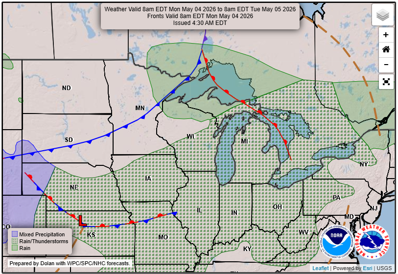
A weak system brings a few spotty showers Sunday, but the better focus comes Monday as a cold front sweeps through. That boundary will bring scattered showers and thunderstorms, along with gusty winds. Forecast soundings suggest enough instability for a few stronger storms, though severe weather is not expected.
“Chances for showers and thunderstorms (30 to 50 percent chances) remains for Monday afternoon and evening, as a cold front moves through the area. Gusty winds could occur with stronger storms.”
– NWS
Winds will be a big part of the story. Southwest gusts ramp up Monday, and behind the front, a cooler air mass settles in for the rest of the week. Overnight lows dropping into the 30s by midweek will bring the return of frost concerns, especially away from Lake Michigan.
East-Central and Northeast Wisconsin: Breezy, Spotty Storms, Then a Late-Week Chill
From the Fox Valley to Door County, the pattern is similar but with a slightly better chance for thunder Monday afternoon.
Two cold fronts move through the region between Sunday and Monday. The second front Monday afternoon brings the best shot at showers and a few thunderstorms, especially across eastern Wisconsin.
“A 40-80% chance of wind gusts over 35 mph on Monday, strongest eastern WI.”
Despite the frontal passage, instability remains limited. That should keep storms below severe levels, though an isolated stronger storm could still produce gusty winds.
By Tuesday, the pattern flips. A broad trough settles in, bringing cooler air and occasional light showers through mid to late week. There is even a signal for mixed precipitation late in the week as colder air deepens aloft.
Frost and freeze potential ramps up quickly starting Tuesday night and may persist for several nights.
Western Wisconsin and the Mississippi River Valley: Limited Rain, Gradual Cooldown
Across western Wisconsin, including La Crosse and surrounding areas, precipitation looks more scattered and less impactful overall.
Most of Sunday and early Monday stay relatively quiet, with only minimal rain chances. The better opportunity for showers and a few storms arrives Monday afternoon and evening, but even here, impacts appear limited.
“Local impacts appear minimal as best synoptic forcing stretches east and south.” – NWS
Temperatures will peak in the upper 60s to low 70s early in the week before dropping off. A cold front stalls across the region midweek, locking in below-normal temperatures and increasing frost potential, especially north and west.
Northern Wisconsin: Windy Shift and a Much Colder Pattern
Northern Wisconsin will feel the biggest temperature swing this week.
Monday brings a sharp transition as a cold front moves through, with strong west winds gusting 30 to 40 mph and possibly higher in spots.
“Westerly winds will increase quickly around sunrise, with gusts of 30 to 40 mph into the daylight hours.” – NWS
Behind that front, a much colder Canadian air mass settles in. Highs will struggle to reach the 40s and 50s midweek, and overnight lows could drop into the 20s in parts of northern Wisconsin.
That sets the stage for hard freeze conditions, especially from Tuesday night through Thursday morning. While precipitation is limited, the cold will be the main story.
By next weekend, temperatures begin to recover as a warmer pattern tries to build back into the Midwest. This is a classic early May setup in Wisconsin. A brief taste of warmth gives way to a reminder that spring can still bite back. Check our Forecast Page for updates and watch our embedded stream live.