
3 Things to Know
- A Severe Thunderstorm Watch is likely this afternoon for southern Wisconsin as storms strengthen and move east.
- Damaging winds up to 80 mph and large hail are the primary threats, with a localized tornado risk where storms interact with a stalled boundary.
- The severe weather threat will increase through the afternoon and evening, so now is the time to review your safety plan and stay weather aware.
If you have outdoor plans this afternoon or evening, now is the time to stay weather aware.
The Storm Prediction Center has issued a Mesoscale Discussion highlighting an increasing risk for severe thunderstorms across southern Wisconsin and northern Illinois. Forecasters say conditions are becoming favorable for severe storms, and a Severe Thunderstorm Watch will likely be issued by around 4 p.m., though it could come sooner if additional storms develop.
What’s Happening?
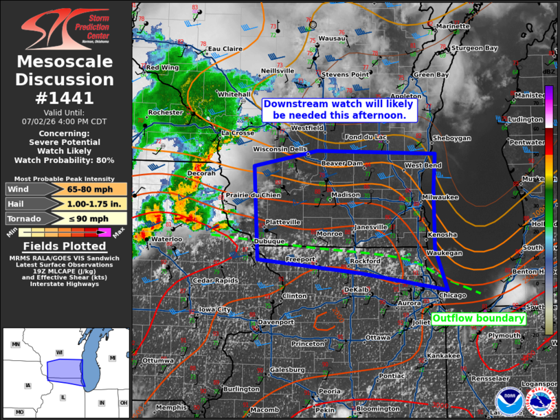
An outflow boundary left behind by this morning’s thunderstorms has stalled across northern Illinois before beginning to drift north this afternoon. As temperatures continue to climb, that boundary will act as a focus for new thunderstorm development.
Meanwhile, powerful thunderstorms already developing to our west are expected to move east into southern Wisconsin through the afternoon and evening.
Main Threats
The strongest storms will be capable of producing:
- Damaging wind gusts of 65 to 80 mph
- Large hail between 1 and 1.75 inches in diameter
- A localized tornado threat, especially where storms interact with the northward-moving boundary
While damaging winds and hail remain the primary concerns, any storm that can remain isolated and track along the boundary could briefly become tornadic.
Timing
The severe weather threat will continue to increase through the afternoon, with storms expected to move into southern Wisconsin later today and continue into the evening.
Because storms are already strengthening to the west, the Storm Prediction Center believes a Severe Thunderstorm Watch is highly likely.
What You Should Do
Now is a good time to review your severe weather plan before storms arrive.
- Keep multiple ways to receive weather warnings.
- Be prepared to move indoors quickly if warnings are issued.
- Secure loose outdoor furniture and decorations.
- If a Tornado Warning is issued, move immediately to the lowest level of a sturdy building and away from windows.
We’ll continue to monitor storm development throughout the afternoon and provide updates as watches and warnings are issued. Stay with Wisconsin Weather Now for the latest radar, alerts and forecast updates.