
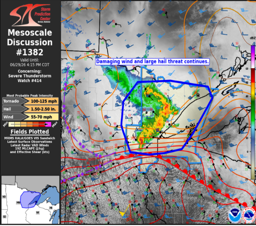
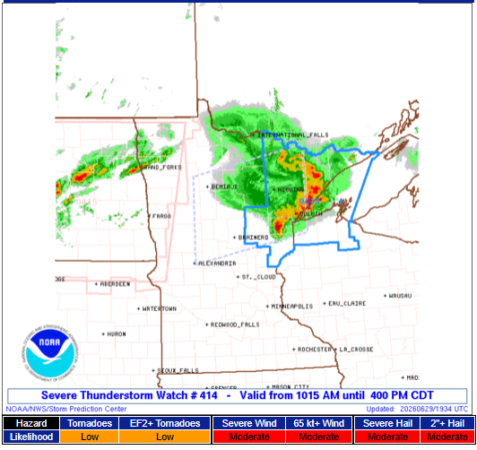
A fast-moving line of severe thunderstorms is racing across northern Minnesota this morning, prompting the Storm Prediction Center to issue a Severe Thunderstorm Watch until 4 p.m. CDT.
The watch is another sign of the active weather pattern setting up across the Upper Midwest. Storms developing today could have implications for surrounding states later as the overall weather system continues east.
Main Threats
Residents within the watch area should be prepared for:
- Damaging wind gusts up to 80 mph
- Large hail up to 2 inches in diameter
- An isolated tornado or two
Forecasters say the storms are expected to remain well-organized as they move northeast through the afternoon, with damaging winds and large hail posing the greatest risk.
What Is a Severe Thunderstorm Watch?
A Severe Thunderstorm Watch means atmospheric conditions are favorable for severe thunderstorms to develop. It does not mean severe weather is occurring everywhere in the watch area, but residents should stay alert and be ready to act if warnings are issued.
Remember:
- Watch: Conditions are favorable.
- Warning: Severe weather is occurring or imminent. Take action immediately.
Looking Ahead
This is the second Severe Thunderstorm Watch issued today across the Upper Midwest as a strong weather system tracks through the region. We’ll continue to monitor its evolution and any potential impacts farther east.
Stay with Wisconsin Weather Now and check our Forecast Page for the latest updates as this active weather pattern continues.