
3 Things To Know:
- Patchy frost is expected tonight.
- Sunny and milder temperatures on Thursday.
- Increasing storm chances starting late this week.
Clear Skies Tonight and Patchy Frost
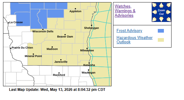
As we move through the overnight, clouds will clear, making way for high pressure settling in. This will lead to mostly clear skies tonight with light winds. Expect temperatures to dip enough to create patchy frost, particularly in eastern areas. If you have sensitive plants or crops, consider covering them this evening.
Milder Temperatures on Thursday
Tomorrow promises to be pleasant, with mostly sunny skies expected throughout the day. Light southerly winds will pick up, allowing temperatures to rise closer to the 70-degree mark away from Lake Michigan. Near the lake, cooler conditions will prevail due to onshore winds.
Increasing Storm Chances This Weekend
Looking ahead, showers are possible Thursday evening into early Friday morning as moisture and warm air move in. However, the most significant weather activity will arrive later this weekend. As we head into Friday, expect plenty of sunshine and warmer temperatures, reaching the upper 70s to low 80s.
“Though a strong to severe storm isn’t out of the question at times Friday night through Sunday, the overall setup for a few strong to severe storms currently looks best on Monday.”
Confidence is building for widespread showers and storms on Monday, with southern Wisconsin expected to be within the warm sector of an approaching low pressure system. Keep an eye on updates as the timing and location of any severe weather will become clearer in the coming days.
For updated forecasts where you live check out our Forecasts Page.
Source: NWS MKX Area Forecast Discussion, issued 2026-05-13T17:18:00+00:00.