
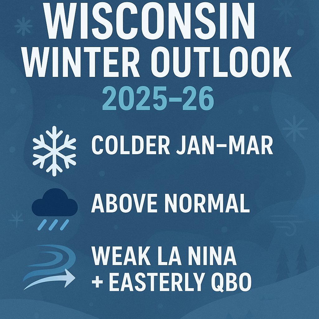
The CPC winter outlook points to a colder, snowier mid-winter for Wisconsin as a weak La Niña strengthens the storm track. Here’s what to expect this season.
The Climate Prediction Center has released its long-lead winter outlook, and Wisconsin is staring down a season that looks more active, colder and snowier than several of the past years. A weak, short-lived La Niña has developed, and while the season may open with milder periods, the heart of winter is showing stronger signals for cold air outbreaks and a steady parade of storm systems.
“La Niña conditions have developed” – CPC
According to the CPC, “La Niña conditions have developed” and are expected to influence the pattern through winter before easing back to neutral by early spring. Historically, La Niña winters steer more storms into the northern states and strengthen a wavy, fast-moving jet stream — the exact setup that often funnels cold air toward Wisconsin.
Another major player this year is the easterly phase of the Quasi-Biennial Oscillation (QBO), a stratospheric wind pattern that can weaken the polar vortex. As the CPC explains, “A weaker stratospheric polar vortex can lead to a more meridional or wavy jet stream… increasing the potential for Arctic air outbreaks.” That combination raises the stakes for January and February.
A Variable Start Before Winter Tightens Its Grip
From November through January, Wisconsin sits in an “Equal Chances” zone — meaning temperatures could swing either way. Expect a mixed early season: pockets of warmth, quick cold snaps, and a blend of rain, wet snow and light early accumulations.
“maximum coverage of favored below-normal temperatures occurs during Jan–Feb–Mar,” – CPC
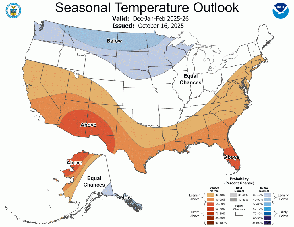
Once we move deeper into the season, the signals strengthen. The CPC points out that “maximum coverage of favored below-normal temperatures occurs during Jan–Feb–Mar,” covering the northern Plains and western Great Lakes — and placing Wisconsin at the center of the coldest early-2026 corridor.
In short: the middle of winter is when the “real winter” arrives.
Wetter Pattern Suggests a More Traditionally Snowy Winter
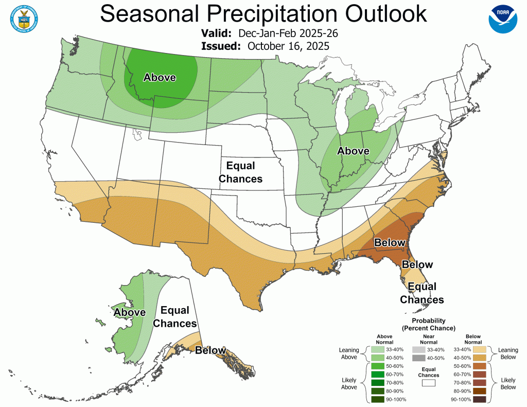
One of the clearest messages for Wisconsin is moisture. From late fall into March, the CPC favors above-normal precipitation across the entire northern tier of the United States, including the Great Lakes. This is classic La Niña behavior.
“an elevated likelihood of above-normal precipitation amounts… eastward to the northern Rockies, Plains and western Great Lakes.” – CPC
The CPC notes “an elevated likelihood of above-normal precipitation amounts… eastward to the northern Rockies, Plains and western Great Lakes.”
For Wisconsin, that could translate to:
- More frequent snow events
- Higher lake-effect potential early on
- A busy and more active storm track
- More chances for mixed precipitation in early winter
The CPC does not predict exact snowfall totals, but increased precipitation combined with colder mid-winter temperatures strongly hints at a more old-school Wisconsin winter.
Watching the Polar Vortex
With La Niña active and the QBO in its easterly phase, the polar vortex becomes a key factor to watch. This setup often weakens the vortex, making disruptions — and Arctic outbreaks — more likely.
“this set of conditions does slightly elevate the potential for colder temperatures in the central and eastern U.S.” – CPC
While not guaranteed, the CPC warns that “this set of conditions does slightly elevate the potential for colder temperatures in the central and eastern U.S.”
A Sudden Stratospheric Warming event could trigger a prolonged deep freeze. If it happens, Wisconsin could be in for a week or more of bitter cold.
How This Winter Could Affect Daily Life in Wisconsin
Travel & Commuting
A more active storm track means more mornings with slick roads, slower commutes and reduced visibility. Early winter may bring more mixed precipitation before colder air dominates mid-season.
Energy & Heating Costs
Any extended cold snaps in January through March will push heating demand higher, creating added financial pressure for many households.
Outdoor Recreation
For the first time in several years, conditions look more favorable for snowmobiling, skiing and ice fishing — especially from mid-January through early March.
Agriculture & Livestock
More snowpack could benefit spring soil moisture, but frequent freeze-thaw cycles may challenge winter wheat and perennials. Cattle operations may see more cold-stress days during outbreaks.
Health & Safety
Expect elevated risks for frostbite, hypothermia and falls on ice. Early-season freezing rain events could increase crash totals and strain emergency services.
Bottom Line for Wisconsin
Expect a winter that’s more classically “Wisconsin”: colder in the heart of the season, wetter overall and active from start to finish. Early winter may wobble between mild and chilly, but the core months — January through March — carry the strongest signal for cold snaps, snow-producing systems and potentially impactful outbreaks of Arctic air.