
Western Wisconsin:
Storm chances, possible ice and heavy rain could impact La Crosse and western Wisconsin this week. Western Wisconsin is stepping into a classic early spring pattern shift, with summer-like warmth quickly giving way to multiple rounds of storms and even a potential return to wintry weather by midweek. Here’s what to expect through the weekend.
3 Things to Know
- Storm chances early: A few strong storms are possible Monday night into early Tuesday near La Crosse and along I-90, with hail and gusty winds the main risks.
- Midweek mess: Wednesday night into Thursday brings a mix of rain, snow and ice, with the highest icing risk north of I-90 and near and north of I-94.
- Heavy rain and rising rivers: Areas south of the wintry mix zone could see 1 to 2 inches of rain, raising concerns for river rises, especially along the Kickapoo River.
A Conditional Severe Threat to Start the Week
The first concern arrives Monday evening into early Tuesday, mainly across southwest Wisconsin and areas near the I-90 corridor, including La Crosse.
Storms are not guaranteed, but if they do develop, the setup supports:
- Quarter-size hail
- Isolated damaging wind gusts
This is a highly conditional setup, meaning many locations may stay dry, but any storm that forms could briefly turn strong. A second window early Tuesday morning could bring additional elevated storms, again favoring areas south of I-90.
Midweek System Brings Winter Back Into the Conversation
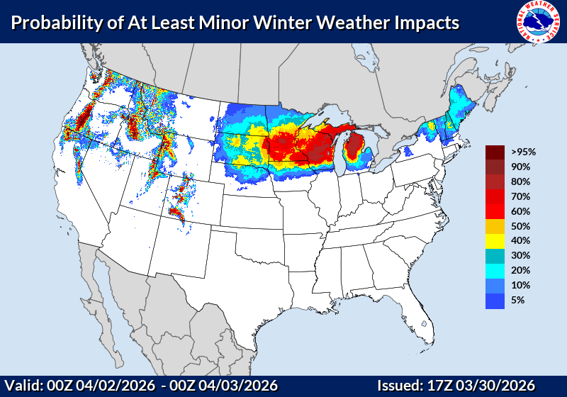
The bigger story unfolds Wednesday night into Thursday as a stronger system tracks out of the southern Plains and into the Upper Midwest.
This is where things get interesting for western Wisconsin:
- A wintry mix zone is expected along and north of I-90, including La Crosse
- Counties like Crawford and Richland could see a mix of rain, snow, and ice
- Farther north, toward Clark and Taylor counties, there is a growing signal for more significant icing potential
Forecast probabilities suggest:
- 40 to 70 percent chance of at least a tenth of an inch of ice
- Around a 30 percent chance of a quarter inch of ice northeast of I-94
Surface temperatures hovering near freezing will make this a very sensitive forecast, especially in the Mississippi River valley where slightly warmer air could limit icing impacts.
Heavy Rain Could Drive River Concerns

South of the wintry mix zone, including parts of southwest Wisconsin and areas closer to the Mississippi River, this system will lean more toward rain.
Rainfall totals could reach 1.5 to 2 inches, especially toward areas closer to Dubuque. That raises concern for:
- Rising rivers and streams
- Potential impacts along the Kickapoo River basin
Given already elevated water levels in some spots, this will be something to watch closely late in the week.
Another Storm Lurks for the Weekend
As if one system wasn’t enough, another strong storm is expected Friday into Saturday.
Right now:
- Western Wisconsin appears to be on the warmer side, favoring rain
- A wintry mix is still possible northwest of La Crosse
- Heavier snow potential looks more likely across central Minnesota and northern Wisconsin
There is still moderate uncertainty with this system, but it reinforces the idea that the active pattern is sticking around.
The Bottom Line for Western Wisconsin
This is a dynamic, high-impact stretch of weather:
- A conditional severe threat early in the week near La Crosse and southwest Wisconsin
- A midweek storm with rain, ice, and snow potential along and north of I-90
- Heavy rain south raising concerns for river rises, especially near the Kickapoo River
- Another storm system heading into next weekend
Spring may be on the calendar, but the atmosphere is not done reminding us it’s still March in Wisconsin. Check our Forecasts Page for updates.