
NORTHEAST WISCONSIN — It’s a classic spring whiplash setup across the region this week, starting with near-summer warmth before transitioning into thunderstorms, and eventually a potentially impactful mix of ice and snow by midweek.
3 things to know
- Storm chances early: Isolated strong storms with hail possible late Monday into Tuesday
- Winter returns midweek: Ice and snow could create travel and power issues Wednesday and Thursday
- Flood risk increasing: Multiple systems may lead to rising water levels by late week
A warm start, but storms are lurking
Monday brought a surge of mild air into northeast Wisconsin, with highs climbing into the upper 60s and even low 70s in some spots. That warmth is helping to fuel the next phase of this pattern, as a developing system approaches from the Plains.
Scattered showers and thunderstorms are expected to develop late Monday into early Tuesday. While widespread severe weather is not expected, a few storms could become strong, with hail up to 1 inch the primary concern.
Confidence remains somewhat limited due to dry air and a stable surface layer, but any storm that can tap into the elevated instability could briefly intensify.
Tuesday: A second chance for storms

As the system shifts east, there’s another window Tuesday afternoon for storms to redevelop, especially across east-central Wisconsin including the Fox Valley.
This setup is conditional. If clouds linger and limit heating, storms may struggle to form. But if breaks in the clouds develop, a few stronger cells could pop. Overall, it’s a low-confidence, low-coverage threat, but one worth watching.
Midweek: From “fake spring” to winter impacts
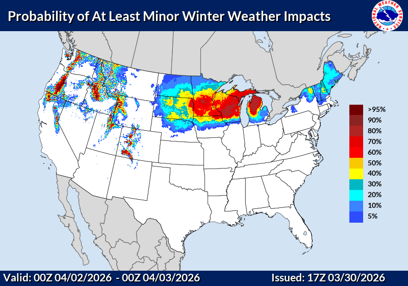
The bigger story arrives late Wednesday into Thursday.
A stronger system lifting out of the Rockies will bring a wide range of precipitation types to northeast Wisconsin. This is where things could get impactful:
- Ice is a growing concern, especially from central Wisconsin into the Fox Valley
- There is a 30% to 50% chance of at least a quarter inch of ice in parts of the area
- Snow is more likely north of Highway 29, where several inches are possible
This setup hinges on a “warm nose” of air aloft, which would favor freezing rain over snow in some areas. That raises the potential for slick roads, tree damage, and power outages if ice accumulates.
Late week: Flood concerns begin to build
As if that wasn’t enough, the pattern stays active into the weekend.
Another system is expected to bring additional moisture, likely in the form of rain. Combined with melting snow and earlier precipitation, this could lead to rising rivers and streams.
Minor flooding is possible in low-lying and poor drainage areas, especially if the wetter scenarios verify.
The bottom line
This is a high-impact, high-variability forecast stretch for northeast Wisconsin. We go from spring warmth to thunderstorms, then right back into winter hazards, all within a matter of days. The exact details, especially with the midweek system, will continue to evolve, but the signal for impactful weather is clearly there. Bookmark our Forecasts Page for updates.