
A powerful spring system brings rain, strong storms, freezing rain and possible snow to Wisconsin through Thursday. Here’s what to expect and where impacts are likely.
3 Things to Know:
- Rain spreads across Wisconsin Wednesday, with pockets of freezing rain and mixed precipitation
- Strong to severe thunderstorms possible Thursday, especially in southern and eastern Wisconsin
- Northern Wisconsin could see accumulating snow while southern areas deal with ice, rain and storms
Storm System Targets Wisconsin
A dynamic spring storm system is set to bring a little bit of everything to Wisconsin over the next 48 hours, with rain, storms, and even a wintry side entering the picture by Thursday.
According to the latest guidance from the Weather Prediction Center, a strengthening area of low pressure will track from the Southern Plains into the Upper Great Lakes by Friday, putting Wisconsin directly in the path of changing conditions.
“A developing wave of low pressure over the Southern Plains on Wednesday will move northeastward to the Upper Great Lakes by Friday.” — NWS Weather Prediction Center
Ice Storm Threat for Central and Northern Wisconsin
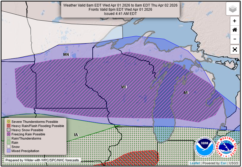
A significant ice storm is expected to develop across central and northern Wisconsin tonight into Thursday, bringing the potential for dangerous and widespread impacts. As precipitation moves in, surface temperatures hovering near freezing combined with a layer of warmer air aloft will create ideal conditions for freezing rain and sleet, especially in areas like Wausau, Stevens Point, Wisconsin Rapids, and into Oneida and Forest counties. Forecasters have issued Ice Storm Warnings where ice accumulation of a quarter inch or more is possible, which is enough to weigh down trees and power lines. Gusty northeast winds of 30 to 35 mph will only add to the threat, increasing the likelihood of power outages and tree damage. Travel conditions are expected to deteriorate quickly overnight into the Thursday morning commute, with icy roads and hazardous conditions likely before temperatures eventually rise and change precipitation over to rain later in the day.
Thursday: Stronger Storms and Severe Risk
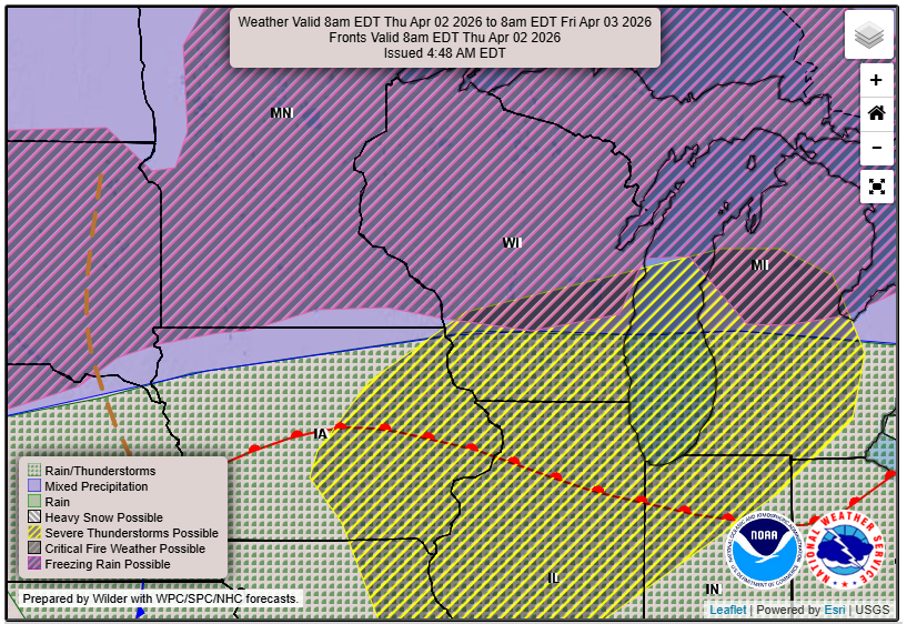
Thursday the system lifts northeast, a stronger push of energy and instability arrives, bringing the chance for thunderstorms across southern and eastern parts of the state. This includes cities like Madison, Janesville, Milwaukee, and Kenosha.
The Storm Prediction Center has outlined a Slight Risk for severe weather across parts of the Upper Mississippi Valley and Great Lakes, which includes Wisconsin.
“The hazards associated with these thunderstorms are frequent lightning, severe thunderstorm wind gusts, hail, and a few tornadoes.” — NWS Weather Prediction Center
Severe Threat Increasing Thursday Afternoon and Evening
Confidence is continuing to grow that Thursday could bring a more organized severe weather threat into southern Wisconsin, especially late in the day and into the evening hours. The Storm Prediction Center has now placed areas along and south of Interstate 94, including Madison, Milwaukee, and Kenosha, in an Enhanced Risk for severe thunderstorms. This setup supports the potential for damaging winds, large hail, and a few tornadoes, some of which could become strong and fast moving as storms track from eastern Iowa into southern Wisconsin. The timing and track of a strengthening surface low moving from Iowa into Wisconsin will be key, helping to focus storms and increase their intensity as they move into the region.
Northern Wisconsin: A Wintry Turn
While southern Wisconsin deals with rain and storms, northern parts of the state may see a return to winter-like conditions.
Heavy snow is expected to develop across portions of the Northern Plains into the Upper Mississippi Valley on Thursday, which could clip northern Wisconsin. Areas near Wausau, Merrill, and into Oneida and Forest counties could see accumulating snow, especially if colder air holds in place.
This setup creates a sharp contrast across the state, with thunderstorms in the south and snow to the north.
Impacts Across Wisconsin
This system has the potential to create a range of impacts depending on location:
- Wet roads and reduced visibility statewide Wednesday into Thursday
- Severe storms Thursday with gusty winds, small hail and possible tornadoes
- Slick travel in northern Wisconsin due to snow or freezing rain
- Localized ponding or minor flooding in low-lying areas
Urban areas and places with poor drainage will be most vulnerable if heavier rain develops.
The Bottom Line
This is a classic spring transition storm for Wisconsin. Expect changing conditions, shifting precipitation types, and at least a low-end severe weather risk on Thursday. Stay weather aware, especially if you have travel plans across different parts of the state where conditions may vary significantly from rain to snow. Check our Forecast Pages for udpates.