

3 Things To Know:
- Elevated fire weather conditions are expected this afternoon in northern Wisconsin.
- Strong to severe storms are likely from Sunday afternoon through Monday night, though timing is uncertain.
- Cooler, drier weather is forecasted for the middle to late part of next week.
Weather Overview
A drier air mass is anticipated to take hold today, leading to a warm and breezy afternoon in the upper 70s to lower 80s. Expect west winds gusting up to 30 mph which has Fire Weather conditions elevated. Strong to severe storms are likely from Sunday afternoon through Monday night, though timing is uncertain.
Fire Weather Concerns
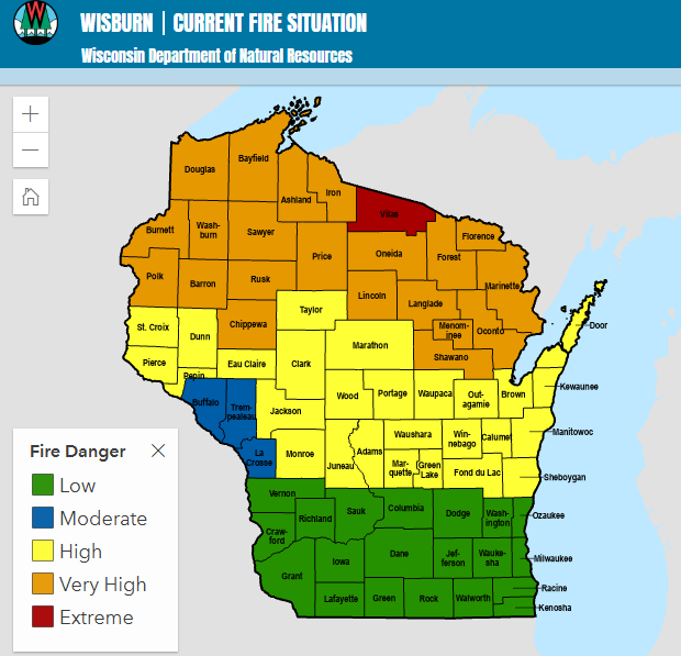
Due to the ongoing dry and windy conditions, there will be elevated to near-critical fire weather conditions across northern Wisconsin this afternoon. Relative humidity could drop as low as 15-25%, creating potential fire hazards. While recent rainfall helped in some areas, dry air could exacerbate conditions.
Severe Storm Outlook

Looking ahead, a warm front will begin to influence the region on Sunday. The day will see an increase in shower and thunderstorm activity from south to north, particularly in central and east-central Wisconsin in the late afternoon. This will lead to a heightened risk of strong to severe thunderstorms overnight. Abundant cloud cover will keep temperatures cooler, ranging from the upper 50s to lower 70s.
“Confidence in the timing and coverage of severe storms is low, but we expect conditions to remain favorable for strong thunderstorms across the region.”
Next Week’s Forecast
As multiple waves of low pressure move through, the possibility of severe storms continues into Monday afternoon and Monday night. Heavy rainfall is also a concern, with varying probabilities for 1+ inches across different regions. Following this system, a return to drier and cooler weather is expected mid to late next week.
For updated forecasts where you live check out our Wisconsin Weather Now Forecasts.
Source: NWS GRB Area Forecast Discussion, issued 2026-05-16T14:38:00+00:00.