
A line of severe storms brought tornado reports, large hail up to 2 inches and wind gusts near 70 mph across Wisconsin Friday evening.
3 Things to Know
- Tornadoes were reported across southern and central Wisconsin, with a cluster near Janesville and Avalon
- Hail up to 2 inches in diameter fell in Rock County, with widespread 1 inch reports
- Wind gusts peaked near 70 mph, especially in northern Wisconsin
Severe Storms Roar Across Wisconsin Friday Evening
A volatile spring setup delivered on its promise Friday, April 17, with multiple rounds of severe thunderstorms racing across Wisconsin. From early afternoon through the evening hours, storms produced tornadoes, damaging winds and large hail, with the most intense activity focused in southern Wisconsin.
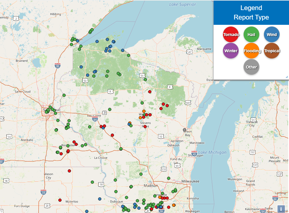
Tornado Reports Cluster in Southern and Central Wisconsin
Several tornadoes were reported across the state, with activity increasing through the late afternoon and peaking around early evening.
The most concentrated reports came from Rock County, including near Janesville and Avalon, where multiple tornadoes were observed around 6 PM. Additional tornadoes were reported earlier in the day across parts of central and western Wisconsin, including near Black River Falls and Osseo.
“Activity ramped up quickly late in the day, with multiple tornado reports in southern Wisconsin as storms intensified.” – WWM Meteorology Team
Large Hail Peaks at 2 Inches
Hail was a major component of these storms, especially across southern Wisconsin where discrete supercells developed ahead of the main line.
- Largest hail: 2.00 inches (hen egg size) near Beloit
- Multiple reports of 1.50 to 1.75 inch hail in Janesville and Milton
- Widespread 1.00 inch hail across Walworth, Jefferson and Dane counties
This corridor from Beloit to Janesville to Milton marked the core of the most intense hail-producing storms.
Damaging Winds Near 70 MPH (not tornado related)
Wind damage reports were more scattered but still significant, especially across northern Wisconsin earlier in the event.
- Peak gust: 68 mph near Minong
- Additional gusts of 60+ mph near Lake Superior communities including La Pointe
- A later non-thunderstorm gust of 55 mph in Ashwaubenon highlighted strong gradient winds behind the storms
Storm Evolution: From North to South
The timeline of reports shows a clear progression:
- Early afternoon: Initial storms develop in western and northern Wisconsin with smaller hail and isolated severe reports
- Mid to late afternoon: Storms intensify moving east, producing hail and the first tornado reports
- Evening: Peak severe threat shifts into southern Wisconsin with tornadoes and the largest hail
- Late evening: Storms organize into a line and begin to weaken while pushing east
What Comes Next
While the most intense severe weather has moved out, lingering showers and gusty winds may continue overnight. Behind the storms, cooler air and breezy conditions are expected heading into Saturday.
This was a classic spring severe weather setup for Wisconsin, featuring discrete supercells, a transition to a line of storms, and a wide range of hazards. More updates will follow as storm reports are finalized and any damage surveys are completed. Here’s the list of the top reports so far:
Here are all Wisconsin storm reports, cleaned up and ranked by category for quick use:
🌪️ Tornado Reports (Latest to Earliest)
- 5 ENE Avalon, WI — 6:09 PM CDT
- 1 N Avalon, WI — 6:09 PM CDT
- 4 SE Janesville, WI — 6:05 PM CDT
- 1 SSW Ringle, WI — 5:05 PM CDT
- 1 SE Weston, WI — 4:51 PM CDT
- 4 NNE Black River Falls, WI — 4:42 PM CDT
- 5 E Osseo, WI — 4:27 PM CDT
- 1 W Osseo, WI — 4:27 PM CDT
💨 Wind Gust Reports (Highest to Lowest)
- 8 WNW Minong, WI — 3:28 PM CDT — 68 MPH
- 1 E La Pointe, WI — 4:15 PM CDT — 66 MPH
- 3 W Ashwaubenon, WI — 7:44 PM CDT — 55 MPH (non-thunderstorm)
- 3 SW Ashland, WI — 3:53 PM CDT — 54 MPH
- 2 ENE Hayward, WI — 3:53 PM CDT — 51 MPH
- 2 ENE Bakerville, WI — 3:40 PM CDT — 51 MPH
- 5 NE Cedar, WI — 4:20 PM CDT — 49 MPH (marine thunderstorm wind)
🧊 Hail Reports (Largest to Smallest)
- 3 E Beloit, WI — 5:29 PM CDT — 2.00 inch
- Beloit, WI — 5:16 PM CDT — 1.75 inch
- Milton, WI — 6:23 PM CDT — 1.75 inch
- 1 WSW Janesville, WI — 6:12 PM CDT — 1.50 inch
- 3 SE Palmyra, WI — 7:02 PM CDT — 1.00 inch
- Eagle, WI — 7:12 PM CDT — 1.00 inch
- 2 S Eagle, WI — 7:25 PM CDT — 1.00 inch
- Watertown, WI — 5:42 PM CDT — 1.00 inch
- 5 SE Belmont, WI — 5:02 PM CDT — 1.00 inch
- Dodgeville, WI — 4:07 PM CDT — 1.00 inch
- Tomah, WI — 3:16 PM CDT — 1.00 inch
- 6 SW Butternut, WI — 5:03 PM CDT — 1.00 inch
- 5 W Park Falls, WI — 4:58 PM CDT — 1.00 inch
- 2 SE Lancaster, WI — 4:22 PM CDT — 0.88 inch
- 1 S Tomah, WI — 3:15 PM CDT — 0.88 inch
- 1 NW Prairie Du Sac, WI — 4:40 PM CDT — 0.75 inch
- Boscobel, WI — 2:03 PM CDT — 0.70 inch
- 1 E Dodgeville, WI — 4:10 PM CDT — 0.50 inch
- Dodgeville, WI — 4:09 PM CDT — 0.50 inch