
The Wisconsin River is at major flood stage near Portage, with a crest forecast Friday morning. Officials warn of levee concerns and urge caution.
3 Things To Know:
- Wisconsin River at Portage is already in major flood stage and still rising
- Crest near 21.0 feet expected Friday morning with levee concerns increasing
- Closures, sandbag efforts, and safety warnings in place across Columbia County
The Wisconsin Department of Natural Resources is warning of a serious and evolving flood situation along the Wisconsin River in Columbia County, as water levels continue to rise into major flood stage.
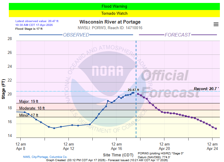
As of early Thursday afternoon, the river reached 19.85 feet near Portage, already classified as major flooding. Forecasts from the National Weather Service indicate the river could crest at 21.0 feet by 7 a.m. Friday, April 17, pushing impacts even higher.
Officials say conditions are changing quickly, and the situation demands close attention from residents and anyone near the river.
“This is a very serious situation. In its present condition and with the predicted crest, the Caledonia-Lewiston Levee should not be expected to provide protection from Wisconsin River flooding with or without human intervention during this flood event,” – Chris Bender, DNR recreation operations supervisor.
Levee Concerns and Closures
The DNR is actively monitoring the Caledonia-Lewiston levee for any signs of stress or failure. At the same time, access to vulnerable areas is being restricted as a precaution.
Pine Island State Wildlife Area is now closed, and officials are urging the public to stay away from levees and nearby flood-prone zones while crews continue their work.
Residents in low-lying areas along the river are being asked to stay alert for updates and be prepared to act if evacuation orders are issued. In the event of a levee failure, emergency alerts will be sent directly to affected areas.
Safety Message: Turn Around, Don’t Drown
Officials continue to stress a critical safety reminder as floodwaters expand across the region.
Driving through flooded roads remains one of the most dangerous decisions during high water events. Just six inches of moving water can sweep a vehicle off the road.
Road closures are already in place across parts of Columbia County, with more possible as conditions evolve. Drivers are urged to obey barricades and never attempt to go around them.
Sandbags and Local Resources
Local officials have made sandbags and sand available for residents preparing for potential impacts:
Residents should bring their own shovel and a vehicle or trailer for transport.
Emergency management officials remain on standby, and residents are encouraged to contact local authorities if they encounter unmarked flooded roads or need assistance.
What to Watch Next
The focus now turns to Friday morning’s projected crest and how the levee system responds under continued pressure. Even after the crest, flooding impacts may linger as water slowly recedes.
Conditions can change rapidly during events like this, and staying informed will be key through the next 24 to 48 hours. Monitor the radar and forecast conditions on our WWN Live Stream page.