
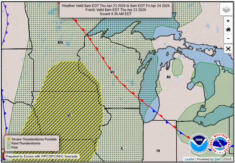
Storms return late Thursday into Friday across Wisconsin with heavy rain and a low-end severe risk, especially west.
3-Things To Know
- Thursday: Warm and dry, highs in the 70s to near 80
- Thursday night: Storms move in west to east, a few strong storms possible west
- Friday: Periods of storms with heavy rain; isolated severe risk lingers
A Warm, Quiet Setup Before Severe Storms Return
Wisconsin gets one more day of spring warmth before the pattern turns active again.
Temperatures will surge into the 70s and even near 80 degrees Thursday afternoon, setting the stage for the next system. While much of the day stays dry, a cold front approaching from the west will bring showers and thunderstorms back into the region late Thursday night and into Friday.
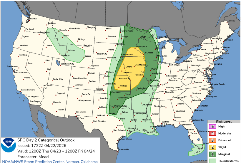
The SPC places a Slight Risk (Level 2 of 5) just to our west, stretching from southern Minnesota into parts of the Plains. Wisconsin sits on the eastern edge of the more favorable severe weather environment, which is key to understanding the risk locally.
- Storms are expected to develop west of Wisconsin Thursday afternoon, especially across Minnesota and Iowa
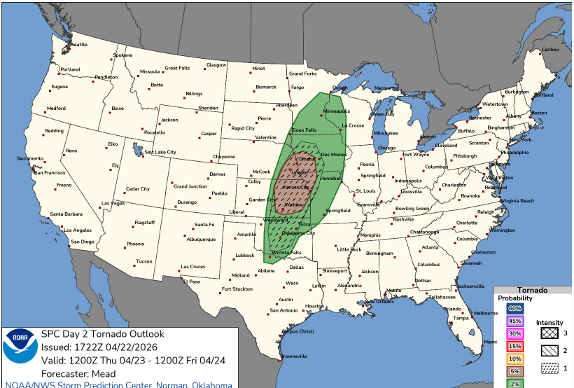
- Those storms may initially be supercells capable of hail, damaging winds, and a few tornadoes
- As they move east into Wisconsin Thursday evening and overnight, they are expected to evolve into a more organized line or cluster
Timing: A Late Arrival, Then Waves of Storms
Confidence continues to increase in the overall timing:
- Thursday daytime: Warm, breezy, and dry
- Late Thursday afternoon/evening (west): Storms begin developing
- Late Thursday night (statewide): Storms move east across Wisconsin
- Friday: Additional rounds or redevelopment possible
Storms are expected to organize into clusters or lines as they move east overnight, then potentially redevelop Friday as the front slowly pushes through.
Severe Weather: Low-End Overall, Higher Risk West
The overall severe threat across Wisconsin remains limited, but it is not zero and varies by location.
What’s changed:
- Western Wisconsin now has a better signal for a few strong to severe storms
- Central and eastern Wisconsin still appear to see weakening storms overnight
Key details:
- Instability increases to 1000–1750 J/kg in western areas
- Storm mode likely becomes messy or linear, limiting widespread severe organization
- Marginal Risk (Level 1 of 5) extends into parts of the region
Main severe threats:
- Gusty to locally damaging winds
- Small to marginally severe hail
- A brief, weak tornado cannot be ruled out, especially with any bowing segments in western Wisconsin
Bottom line:
This is still not a classic severe outbreak setup, but there is enough instability and forcing for isolated stronger storms, especially west of Madison Thursday evening.
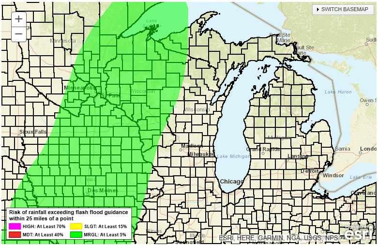
Main Concern: Heavy Rain and Localized Flooding
Heavy rainfall continues to stand out as the primary impact.
- Most areas: 0.5 to 1 inch likely
- Localized totals: 1.5 to 2 inches possible
- Broader guidance still supports a 20 to 40 percent chance of 1 inch or more
Storms will be fairly progressive, which should limit widespread flooding, but:
- Repeated storms or training cells could cause ponding and localized issues
- Rivers and streams are already elevated in parts of the state
This keeps the flood risk localized but worth watching closely.
Bottom Line for Wisconsin
- The highest severe risk stays west of the state, especially into Minnesota and Iowa
- Wisconsin will likely see storms on the weakening side of the system
- Still, a few strong storms are possible, especially in western Wisconsin early Thursday evening
- By the time storms reach eastern Wisconsin overnight, the main impacts shift to gusty winds and heavy rain
This is a classic Upper Midwest setup where Wisconsin is close enough to the action to see impacts, but just far enough east to avoid the core of the severe threat—at least based on current trends.
Friday: Not Done Yet
As the front moves through Friday:
- Showers and storms may redevelop late morning into the afternoon
- Cloud cover may limit instability, but
- An isolated stronger storm remains possible
Additional rounds of heavy rain are possible, especially if storms redevelop along the front.
Final Take
Think of this as a “messy spring storm system”:
- Not organized enough for a major severe outbreak
- But active enough to bring heavy rain and a few stronger storms
We’ll continue to fine-tune timing and severity as higher-resolution data comes in, especially for Thursday evening in western Wisconsin.