
Multiple rounds of severe storms hit Wisconsin April 13-17, 2026, producing tornadoes, large hail, damaging winds and widespread flooding.
3 Things To Know
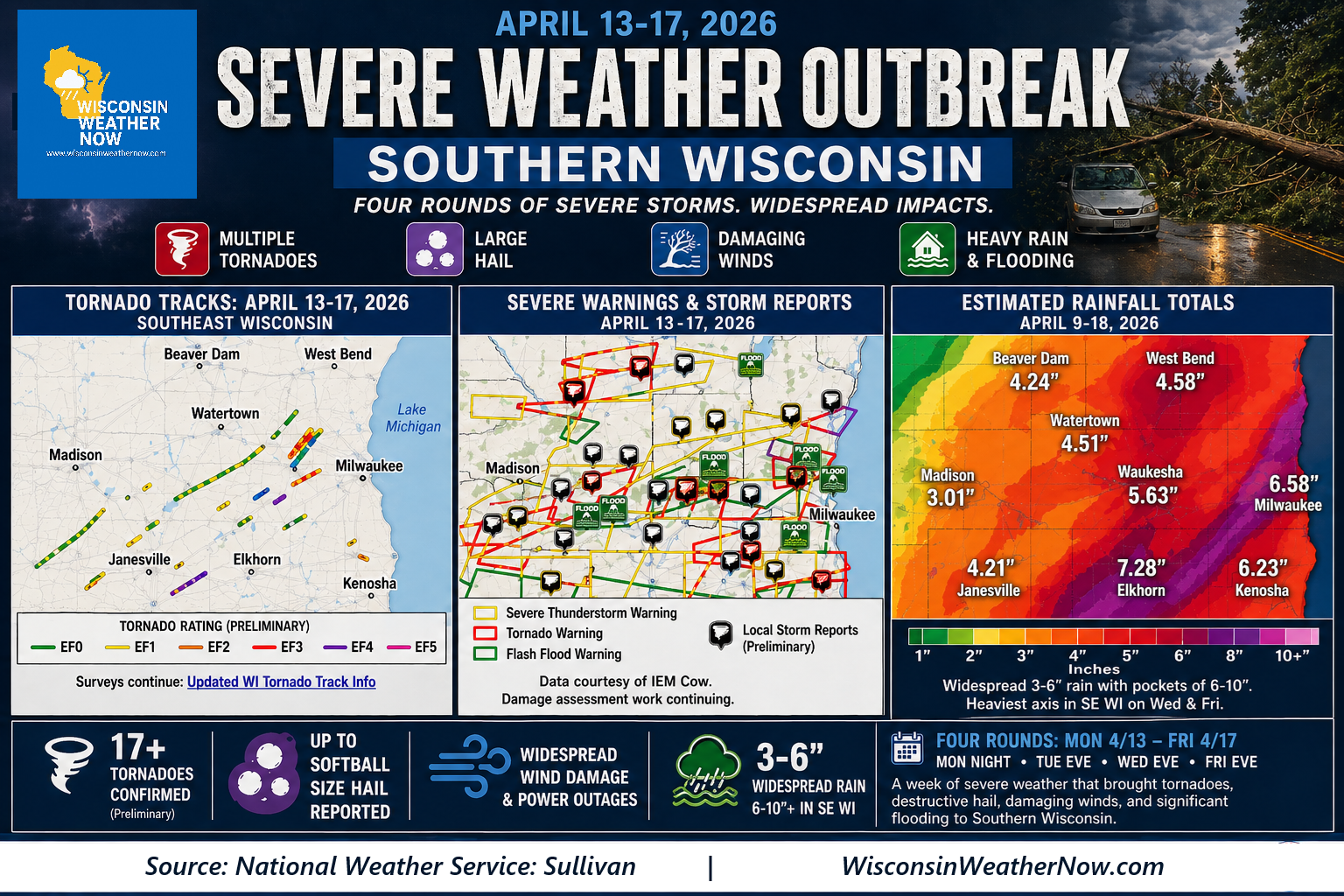
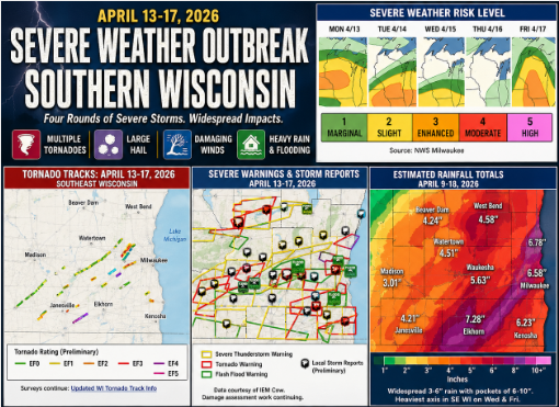
- Four rounds of severe storms from April 13-17 produced tornadoes, large hail and widespread wind damage across southern Wisconsin
- Rainfall totals of 3 to 10 inches led to flash flooding and rising rivers, especially in Milwaukee and Janesville
- A total of multiple tornadoes were confirmed across the week, with the most active days on April 14 and April 17
SOURCE: NWS Sullivan
A prolonged and active stretch of weather brought multiple rounds of severe storms across southern Wisconsin during the week of April 13-17, 2026. The event unfolded in four distinct waves, each producing a mix of hazards including tornadoes, damaging winds, large hail and significant flooding. By the end of the week, the cumulative impacts highlighted both the persistence of the pattern and the compounding effects of repeated storms over the same areas.
“This was the first of four significant rounds of severe weather to impact southern Wisconsin during the week of April 13-17, 2026.”
A Multi-Day Severe Weather Pattern
The outbreak began Monday night, April 13, with a line of storms producing widespread straight line wind damage and at least two tornadoes. These storms strengthened overnight as wind shear increased, evolving into a more organized system capable of rotation and embedded tornadoes. Power outages and tree damage were reported across much of southern Wisconsin.
On Tuesday, April 14, conditions became even more favorable for severe weather as a warm front surged north. Discrete supercells developed during the afternoon, producing very large hail, including stones up to softball size in the Madison area. Six tornadoes were confirmed that day, along with numerous reports of damaging winds and flash flooding.
Storms continued on Wednesday, April 15, as a stalled frontal boundary kept the atmosphere primed for additional development. While this round produced fewer tornadoes, it brought heavy rainfall and additional flooding concerns. One confirmed tornado near Elkhorn and multiple funnel cloud reports highlighted the continued severe threat. Rainfall totals of 1 to 3 inches fell on already saturated ground, worsening flood conditions.
Thursday provided a brief break in severe weather, but the pattern quickly reloaded.
Final Round Brings Widespread Impacts
The final and most expansive round arrived Friday, April 17, bringing another surge of severe thunderstorms across the region. A mix of supercells and storm clusters produced large hail, damaging winds and multiple tornadoes. Eight additional tornadoes were confirmed, with activity stretching from Rock County east into Racine, Kenosha and southern Milwaukee counties.
Heavy rainfall during this final round compounded flooding issues, particularly in the Janesville area where water rescues were reported. Repeated rounds of storms over the same locations led to rapid runoff and overwhelmed drainage systems.
Flooding Becomes a Major Story

While tornadoes and hail drew much of the attention, flooding emerged as one of the most impactful aspects of the outbreak. Over the course of the week, widespread rainfall totals of 3 to 6 inches were common, with some areas receiving as much as 6 to 10 inches.

Flooding At American Family Field
The heaviest rain fell in southeastern Wisconsin, where flash flooding hit the Milwaukee metro area midweek and the Janesville area later in the week. Rivers including the Wisconsin and Rock rose significantly, and major roadways were temporarily shut down due to high water.
The Big Picture
This event stands out not just for the severity of individual storms, but for the repeated nature of the pattern. Multiple rounds of severe weather over several days increased the overall impact, especially as soils became saturated and recovery time between events was limited.
The combination of tornadoes, destructive hail, damaging winds and flooding underscores how dynamic spring weather patterns can be in the Upper Midwest. It also serves as a reminder that prolonged severe weather setups can be just as impactful as a single high-end outbreak.
To monitor future severe weather outbreaks or any active weather, check out our new embedded WWN Live Stream featuring live radar, up to date warnings and next day forecasts.