
3 Things To Know:
- Thunderstorms may develop this afternoon, especially southeast of a line from Darlington to Sheboygan.
- A Gale Warning is in effect for parts of Lake Michigan until late afternoon.
- Expect warmer and more humid conditions with increasing storm chances later this week.
Gale Warning for Lake Michigan
A Gale Warning is currently in effect for the middle third of open waters of Lake Michigan, including the nearshore zone from Sheboygan to Port Washington, until 5 PM today. Winds could be gusty across these areas, and boaters should exercise caution. If you’re near the water, keep an eye on conditions as changing weather can impact safety.
Gusty Wind and Spotty Storms Sweep Across Southern Wisconsin
Strong winds took center stage across southern Wisconsin Tuesday evening as clearing skies behind the morning rain helped fuel deep atmospheric mixing. That process allowed stronger winds higher in the atmosphere to mix down to the surface, leading to widespread wind gusts of up to 40 knots across the region.
A Wind Advisory remained in effect through the evening as the strongest daytime heating and mixing gradually faded after sunset.
Cold Front Moving Through Wisconsin
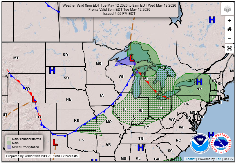
As of early evening, a cold front stretched roughly from Sheboygan County southwestward to Rock County. Spotty showers and a few isolated thunderstorms developed ahead of the boundary, mainly across east-central Wisconsin.
Forecasters noted a decrease in cumulus cloud development over southeast Wisconsin, signaling that most of the storm activity would likely remain north of Interstate 94 as the front continued pushing east-southeast through the state.
What to Expect Tonight
- Windy conditions gradually ease after sunset
- Spotty showers and isolated thunder remain possible, mainly north of I-94
- Brief strong wind gusts remain the primary concern
- Small hail cannot be ruled out in stronger storms
Looking Ahead
Following today’s storm potential, conditions will cool down slightly as the front moves through. Expect some clearing this evening, although clouds will likely fill back in overnight. Tomorrow’s temperatures will be in the lower 70s, influenced by a cooler air mass.
As we move into Thursday and the weekend, warmer and more humid conditions will return, with increased moisture in the atmosphere. This will lead to more chances for showers and thunderstorms on Thursday night and potentially into Friday.
Stay informed for updates on this evolving weather situation.
“By mid-afternoon, showers south of I-94 will wind down, but the possibility for thunderstorms remains.”
As we prepare for changing weather, make sure to check the latest updates for your specific area.
For updated forecasts where you live check out our Forecasts Page.
Source: NWS MKX Area Forecast Discussion, issued 2026-05-12T18:18:00+00:00.