

Multiple rounds of showers and thunderstorms could produce 3 to 6 inches of rain or more in parts of Wisconsin through Saturday, raising the threat of flash flooding.
3 Things to Know
- Flood Watches cover a large portion of southern Wisconsin, including Madison, Milwaukee, Waukesha, Racine, Kenosha, Janesville and communities west toward La Crosse.
- Widespread rainfall of 1 to 3 inches is expected, but repeated thunderstorms could push localized totals into the 3- to 6-inch range or higher.
- Saturday remains especially concerning. Extremely high atmospheric moisture and storms repeatedly tracking over the same areas could produce rainfall rates exceeding 2 inches per hour.
Flood Watches are expanding across much of southern Wisconsin as a very moist weather system threatens to bring repeated rounds of heavy rain through Saturday.
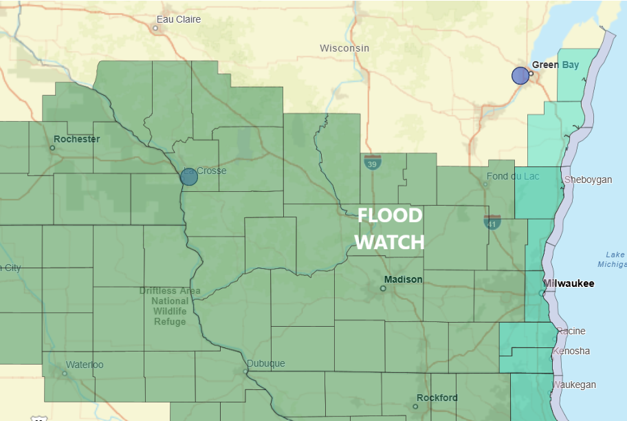
The National Weather Service says widespread rainfall totals of 1 to 3 inches are expected across southern Wisconsin. Where thunderstorms repeatedly move over the same locations, locally 3 to 6 inches or more could fall.
That raises a significant concern for flash flooding, particularly in urban areas, low-lying locations and places that have already received heavy rainfall recently.
Flood Watches Expand Across Wisconsin
A Flood Watch is in effect across portions of western and southwestern Wisconsin from 7 p.m. Friday through Saturday afternoon.
That includes Adams, Buffalo, Crawford, Grant, Jackson, Juneau, La Crosse, Monroe, Richland, Trempealeau and Vernon counties.
Farther east, the National Weather Service in Milwaukee/Sullivan has issued a Flood Watch from 1 a.m. Saturday through Saturday afternoon for a large portion of southern Wisconsin.
That watch includes Columbia, Dane, Dodge, Fond du Lac, Green, Green Lake, Iowa, Jefferson, Kenosha, Lafayette, Marquette, Milwaukee, Ozaukee, Racine, Rock, Sauk, Sheboygan, Walworth, Washington and Waukesha counties.
Creeks and streams could rise out of their banks, while flooding may develop in urban and poor-drainage areas. Excessive runoff could also overwhelm storm drains and ditches.
Heavy Rain Threat Begins Friday
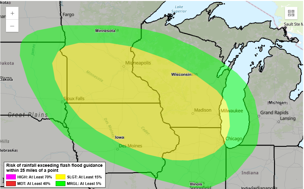
The Weather Prediction Center has placed portions of the Upper Mississippi Valley and Midwest in a Slight Risk for excessive rainfall through early Saturday.
The highest rainfall totals during this initial period are expected to focus on southeast Minnesota and west-central Wisconsin.
However, updated forecast guidance has shifted heavier rainfall potential farther east into southeastern Wisconsin and northeastern Illinois.
That is important because some of these areas have received heavy rainfall recently, leaving them more sensitive to additional downpours.
Saturday Could Bring Another Round
The flooding concern does not end Saturday morning.
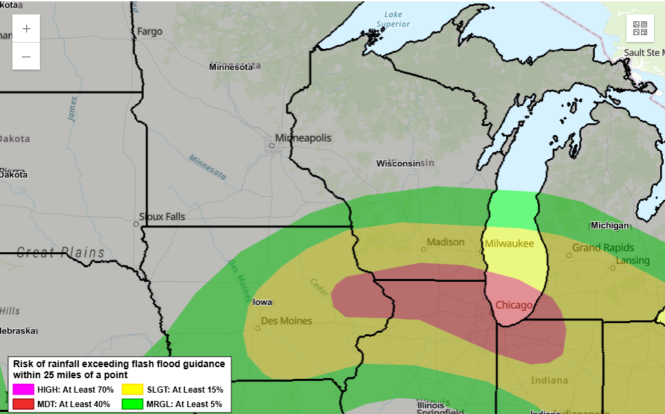
The Weather Prediction Center has issued a Moderate Risk for excessive rainfall Saturday into early Sunday from eastern Iowa through northern Illinois and northern Indiana. The risk area also reaches into far southern Wisconsin.
Forecasters are increasingly concerned about multiple rounds of thunderstorms developing along a slow-moving boundary.
Exactly where the heaviest rain develops remains uncertain and could depend heavily on what happens with storms Saturday morning. Persistent clouds and rain could shift where the atmosphere becomes most unstable later in the day.
Still, confidence is increasing that additional thunderstorms will develop.
An Atmosphere Loaded With Moisture
The amount of moisture available to these storms is unusually high for September.
Precipitable water values, a measure of how much moisture is available through the atmosphere, are forecast to reach around or above 2 inches. The Weather Prediction Center says those values are above the 99th percentile for mid-September.
In other words, there will be plenty of moisture available for thunderstorms to turn into very efficient rain producers.
Some storms could produce rainfall rates of more than 2 inches per hour.
Training Storms Are the Biggest Concern
One of the biggest flood concerns is something meteorologists call training.
Instead of one storm passing through and moving away, new thunderstorms can repeatedly develop and travel over the same locations, much like train cars moving along the same track.
When that happens, rainfall totals can pile up quickly.
The National Weather Service says southern Wisconsin could generally receive 1 to 3 inches, but bands of repeated storms could produce 3 to 6 inches or more.
Where those heavier bands set up will make a major difference in who experiences flooding.
Flash Flooding Could Develop Quickly
Not everyone under the Flood Watch will receive extreme rainfall, and a Flood Watch does not mean flooding is occurring.
It means conditions are favorable for flooding or flash flooding to develop.
Areas most vulnerable include:
- Urban streets and underpasses
- Low-lying and poor-drainage areas
- Small creeks and streams
- Locations that recently received heavy rain
- Roads near rapidly rising waterways
Drivers should never attempt to cross a flooded roadway. Water can be deeper and moving faster than it appears, and roads underneath floodwater may be damaged or washed out.
People living in flood-prone areas should keep a close eye on forecasts, warnings and changing conditions through Saturday.
Bottom Line
This is shaping up to be a multi-round heavy rain event rather than one quick line of storms.
The first significant round arrives Friday night into Saturday morning, but additional thunderstorms may develop Saturday. With unusually high atmospheric moisture in place, any location hit repeatedly could see rainfall totals climb rapidly.
The exact corridor of heaviest rain remains uncertain, but with Flood Watches covering much of southern Wisconsin, this is a forecast worth monitoring closely through Saturday.
