
A Winter Preview By Wisconsin Weather Now
October 18, 2025
A major weather pattern shift is developing across North America — and it could be the first real sign that winter is on the way for Wisconsin and the Upper Great Lakes.
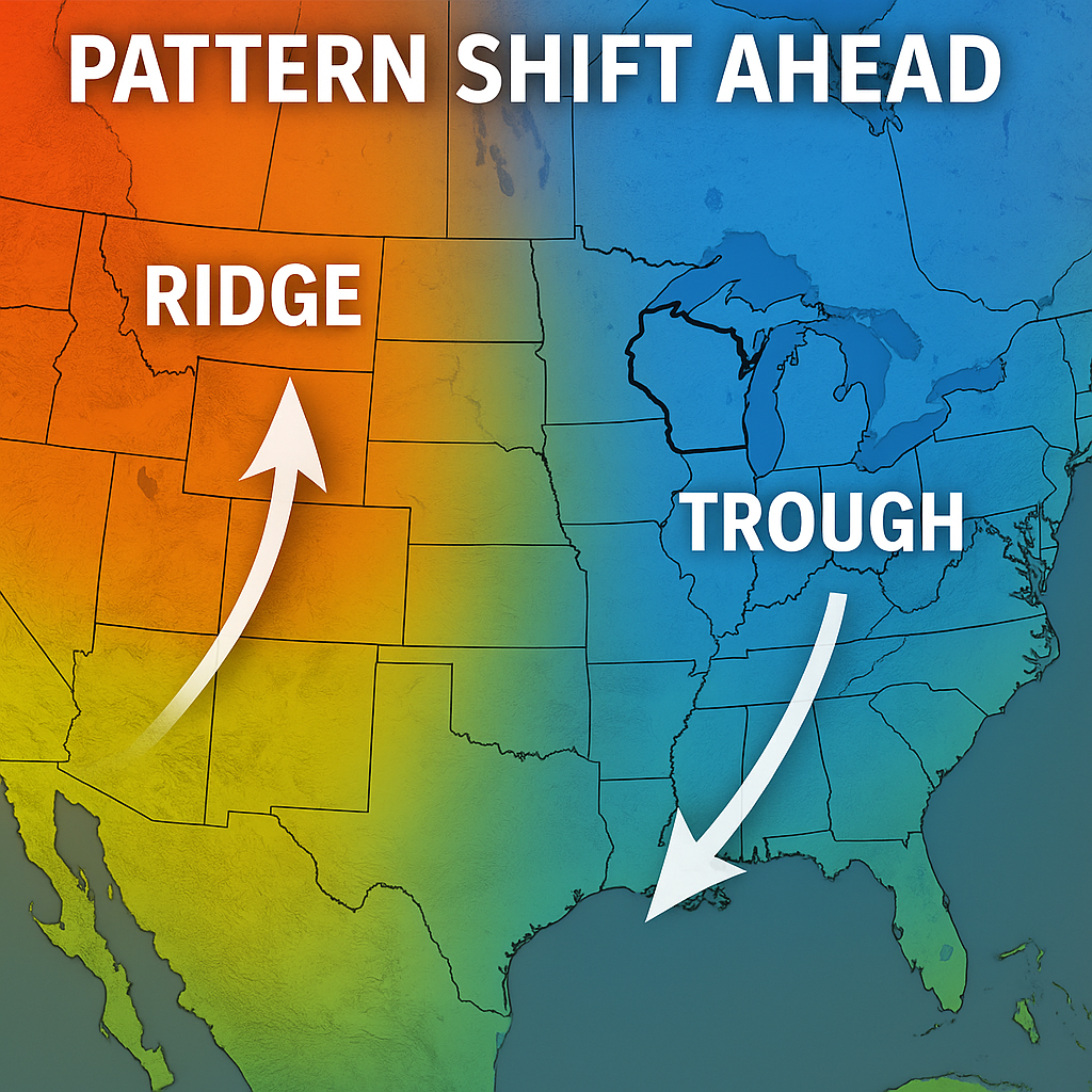
According to the National Weather Service’s Weather Prediction Center, a closed low-pressure system will spin over the Great Lakes early this week while a strong ridge of high pressure builds across the western U.S. The result: a classic “trough east, ridge west” setup that often ushers in the first sustained cool-down of the season.
Before you reach for the parka, stay up-to-date on short-term trends with our Wisconsin Forecast Pages and check live conditions anytime on the WWN Interactive Radar.
Trough East, Ridge West — The Setup Behind the Winter Shift
Meteorologists describe this as a jet-stream bend: upper-level winds climb north across the Rockies, then dip south over the eastern U.S., steering cooler air out of Canada and into the Great Lakes. When that pattern locks in, it tends to favor chilly, unsettled stretches across Wisconsin and milder, drier weather to the west.
This week’s system will bring gusty northwest winds and off-and-on lake-effect showers, especially near Lake Michigan and Lake Superior. It’s not an Arctic blast — but it’s a firm nudge toward late-October norms.
Average highs: upper 40s to mid-50s
Average lows: low 30s to around 40
Next warmup window: Late week as the ridge expands eastward
Track temperature swings in your area anytime on the WWN Local Forecast Page.
Why Meteorologists Are Watching This Winter Pattern
The Climate Prediction Center’s long-range maps show the Great Lakes trending cooler and wetter than normal through early November. Add in the ongoing La Niña Watch — which typically strengthens the northern jet stream — and the stage is set for a stormier, snowier late fall.
“This is the kind of setup we often see just before the first measurable snow in northern Wisconsin,” said an NWS forecaster. “It doesn’t mean winter starts next week — but it’s the beginning of that atmospheric hand-off.”
What to Expect This Week
- Cooler, windier days with scattered lake-effect showers.
- First flurries possible in far northern Wisconsin and the U.P.
- Brief rebound in temps by late week.
- Early signs of a pattern that could evolve into winter’s framework.
Now’s the time to check the furnace, clear the gutters, and dust off the snow shovel. Wisconsin’s long, slow slide toward winter looks to be starting right on schedule.
🔗 Keep Up With the Change
- 📡 WWN Radar Hub – Live precipitation and wind gusts.
- 🌤️ Extended Forecasts – Your 7-day outlook for Milwaukee, Madison and beyond.
- ❄️ La Niña and Winter Outlook – How this Pacific pattern could shape our snow season.