
3-Point Brief
- Above-average temperatures are limiting snow cover across much of Wisconsin heading into Christmas.
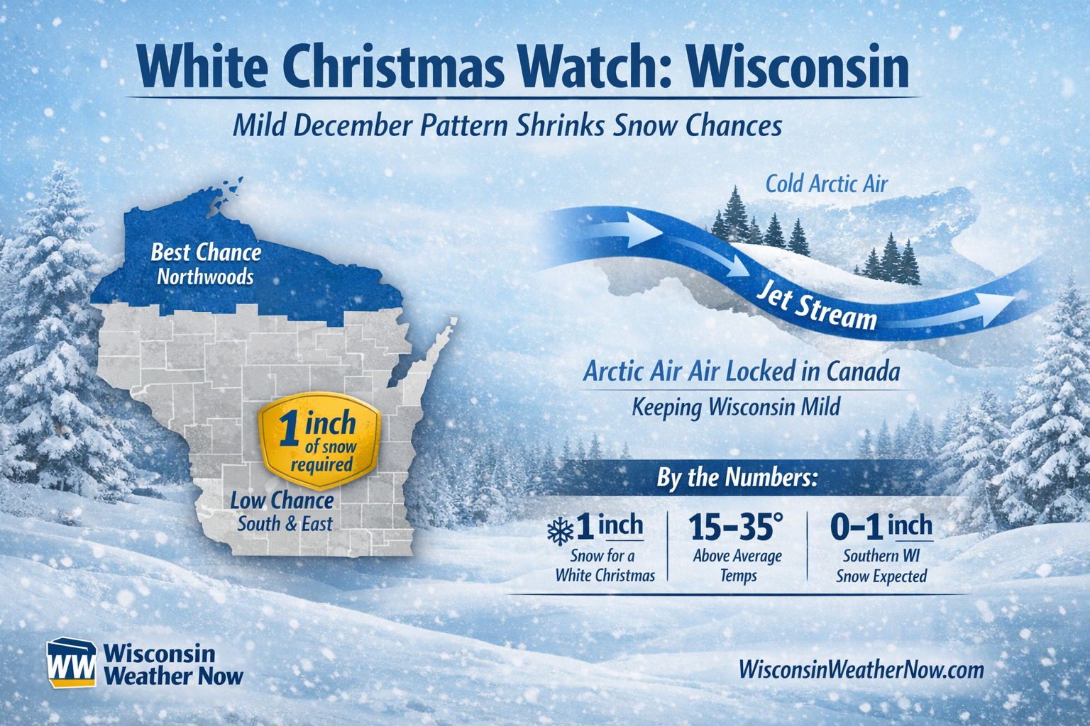
- Northern Wisconsin has the best chance to meet the 1-inch snow-on-the-ground definition of a white Christmas.
- A fast-moving weather pattern is keeping Arctic air locked in Canada through midweek.
For many across Wisconsin, this week will look and feel more like late fall than the heart of winter. A persistent mild weather pattern across much of the Lower 48 is limiting snow chances and keeping temperatures well above normal, shrinking the odds of a white Christmas for large parts of the state.
The latest forecast from the Weather Prediction Center shows no major Arctic air intrusions into the Midwest through midweek, with only light precipitation expected across the Great Lakes.
“This will keep arctic air out of the Lower 48, with it remaining north of the border across Canada and Alaska.”
What Counts as a White Christmas?
Meteorologically, a white Christmas is defined as 1 inch or more of snow on the ground on Christmas morning. Falling snow alone does not qualify. You need snowpack that survives into Dec. 25.
In Wisconsin, that typically favors the northern tier of the state, where colder temperatures help preserve existing snow cover.
Where Wisconsin Still Has a Chance
While much of southern Wisconsin may remain snow-free, parts of northern Wisconsin still have a realistic shot at meeting the minimum threshold.
Areas near Rhinelander, northern forest counties and locations closer to Lake Superior typically hold snow longer this time of year. Meanwhile, cities such as Green Bay and Milwaukee often need fresh snow close to Christmas Day to qualify.
“This much above average to record high temperature pattern will persist into Christmas, limiting any chances of a white Christmas.”
Why December Feels More Like November
The reason for the missing winter chill comes down to the jet stream. A strong west-to-east flow is keeping storm systems fast-moving and preventing cold Canadian air from diving south.
According to the WPC, temperatures across much of the country are running significantly above average.
“High temperatures are forecast to be 15 to 35 degrees above average.”
That same pattern is bringing historic rainfall to California while leaving Wisconsin with relatively quiet weather and limited snow opportunities.
By the Numbers: Wisconsin’s White Christmas Outlook
- 1 inch – Official snow depth required on Christmas morning for a white Christmas
- 15–35 degrees – How far above average temperatures are running across parts of the Lower 48
- 0–1 inch – Expected snow amounts for much of southern Wisconsin this week
- Best odds – Far northern Wisconsin, including the Northwoods
- Lowest odds – Southeast Wisconsin, including Milwaukee
What to Expect Through Christmas Eve
While light to moderate precipitation is possible across the Great Lakes early in the week, impacts in Wisconsin look minimal.
“A quick moving area of low pressure… will produce generally light to moderate precipitation amounts from the Great Lakes into the Northeast.”
Any snow that does fall is expected to be light, with marginal temperatures making it difficult for snow to accumulate or stick around in southern parts of the state.
Looking Ahead
The lack of snow on the holiday does not mean winter is over. Patterns can change quickly later in December and January, and Wisconsin has seen plenty of cold and snowy finishes following mild starts.
For now, though, the holiday forecast leans mild, quiet and mostly snow-free for much of the state, with the best chances for a classic white Christmas confined to far northern Wisconsin.