
A major pattern shift could bring much warmer air into the central U.S. next week. Here’s how much of that warmth could reach Wisconsin — and how long it may last.
- A large-scale pattern shift may allow much warmer air to expand eastward early next week
- Wisconsin could see noticeable temperature moderation after a cold start to Sunday and Monday
- Forecast confidence drops midweek as models diverge on how the pattern evolves
February Fake-Out? Wisconsin Watches for a Potential Warm Surge Next Week
Wisconsin’s extended forecast is shaping up to be a classic February tug-of-war, with winter cold holding on early — but a notable warm-up signal building just beyond it.
According to the latest extended forecast discussion from the Weather Prediction Center, a major pattern shift is expected to unfold across the United States as we head into next week, allowing much warmer air to surge eastward out of the Plains.
“The pattern is forecast to translate eastward, with the ridge bringing much above average temperatures to the central U.S., and temperature moderation even into the East as the week progresses.”
Cold Start, Then a Change
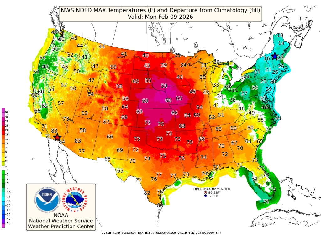
Before any talk of warmth, Wisconsin still has one more cold shot to contend with. The WPC notes that the eastern third of the country — including the Great Lakes — will begin the period well below normal.
“Eastern parts of the Ohio Valley into the Mid-Atlantic and Northeast can expect temperatures that are below average by 15 to 25 degrees on Sunday.”
That means Sunday morning will feel sharply winter-like across Wisconsin, especially inland and north, with subzero readings possible in colder spots and wind chills reinforcing the bite.
The good news? That cold air does not appear to be locked in for long.
Warm Air Presses East — How Far Does It Get?
As we move into early and midweek, attention turns to a strong ridge building across the central U.S. This feature is responsible for some eye-popping temperature anomalies just west of Wisconsin.
“The Plains will see the greatest anomalies of 20–30 degrees above normal for early February.”
While highs in the 60s for Montana and the Dakotas won’t make it into Wisconsin, the broader signal suggests moderation is likely, especially for southern parts of the state. Highs edging closer to seasonal or slightly above-normal levels become more plausible by Tuesday and Wednesday.
Why Warm Air Confidence Drops Midweek
Despite the warmer signal, the WPC stresses that details beyond early next week are far from settled. Model guidance diverges on how southern-stream energy and Canadian troughing interact — a setup that often leads to forecast adjustments.
“The flow behind it is somewhat uncertain…”
In plain terms: Wisconsin sits near the battleground between lingering cold air to the east and much warmer air to the west. Small shifts in the pattern could make a big difference in just how mild things feel — and how long it lasts.
Bottom Line for Wisconsin
This looks less like an early spring arrival and more like a temporary February thaw — a warm-up worth noting, but not one to trust blindly.
Winter still has a say in the forecast, and as the pattern reshuffles, expect refinements in both temperature and precipitation chances as we move through the week.
Stay tuned. In February, nothing comes easy — especially warmth.