
Dangerous Arctic cold lingers across Wisconsin through Sunday before a gradual warm-up early this week. Here’s why winter isn’t finished yet.
- Dangerous Arctic cold holds through Sunday, with wind chills posing the greatest risk despite limited snowfall.
- Temperatures begin to moderate Monday and Tuesday, rising roughly 10 degrees per day, improving travel and outdoor conditions.
- This is not a pattern change winter remains in control, with additional clipper systems still possible in the week ahead.
Wisconsin is in the grip of the coldest air of the winter season, but relief is finally in sight. The key word, though, is relief, not spring.
According to the National Weather Service’s Weather Prediction Center, a dangerous Arctic airmass will remain locked over the Great Lakes through Sunday before gradually loosening its grip early this week.
“A bitterly cold Arctic airmass that has overspread the eastern Great Lakes… is expected to persist through Sunday.”
Sunday is the day to take the cold seriously. While snowfall is limited, the combination of frigid air and lingering winds is the real concern, especially during the morning hours.
“Lingering gusty winds will lead to dangerously cold wind chills… particularly through the morning hours.”
For much of Wisconsin, this means subzero wind chills to start the day, with conditions improving only slowly through the afternoon. Outdoor work, pets, and extended exposure all remain high-risk until winds ease and temperatures begin their climb.
The Winter Turnaround Begins — Slowly
The good news arrives early this week, as temperatures finally begin to recover.
“Conditions are expected to moderate through the early part of the week, with highs Monday and Tuesday increasing by around 10 degrees or so each day.”
That warming trend will be noticeable. Morning lows won’t be as punishing, and afternoon highs will feel more manageable compared to the deep freeze of the weekend. For commuters, it’s a meaningful improvement — but it’s not a pattern change.
Not a Spring Flip
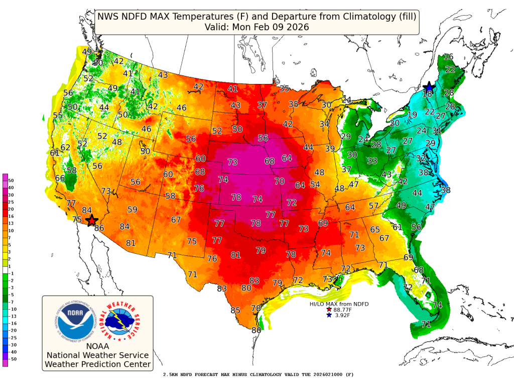
With headlines elsewhere screaming about 60s and 70s across the Plains, it’s tempting to think winter is waving the white flag. That’s not the case in Wisconsin.
“Warmer-than-average conditions will continue into the early part of next week across much of the central to western U.S.”
The key phrase there is central to western U.S. Wisconsin sits on the colder side of the jet stream, meaning we’ll feel moderation, not warmth. February standards still apply, and colder air remains close enough to support additional systems.
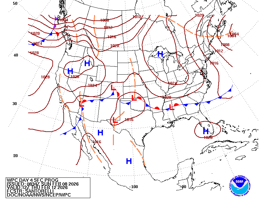
In fact, the WPC notes that a clipper-like system will track near the U.S.–Canadian border Monday, bringing another chance for light snow or spotty icing in parts of the Upper Great Lakes.
Bottom Line for Wisconsin
This is the end of the worst cold, not the end of winter.
Sunday is about safety and survival in the Arctic air. Monday and Tuesday bring improving conditions and a break from extreme cold, but February isn’t done delivering winter weather yet. The pattern favors ups and downs — and clippers are still in play.
The takeaway: enjoy the moderation, but keep the winter coat handy.