

The Pacific Ocean is turning up the heat, and the implications for Wisconsin’s upcoming winter could be significant. The latest update from the National Oceanic and Atmospheric Administration (NOAA), released Thursday, Oct. 8, confirms that El Niño continues to strengthen, with a strong to very strong event likely to persist through the winter months.
More importantly, forecasters say there is an 83% chance El Niño will reach historic intensity during the October-December period, potentially surpassing the strongest events recorded since 1950. That doesn’t mean Wisconsin is guaranteed a mild winter, but it does suggest the atmosphere could be in for an interesting ride.
3 Things to Know
- Historic strength possible: NOAA forecasts an 83% chance of El Niño reaching or exceeding the historic strength threshold during October-December.
- Winter implications: Strong El Niño events historically favor milder conditions across parts of the northern United States, including Wisconsin, although individual winter storms remain possible.
- Not a winter forecast: El Niño influences seasonal weather patterns, but it doesn’t determine exactly how much snow Wisconsin will receive or how cold individual weeks will be.
El Niño : Pacific Ocean Temperatures Are Soaring
El Niño develops when ocean temperatures in the central and eastern tropical Pacific rise above normal, triggering changes in atmospheric circulation that can influence weather patterns around the globe.
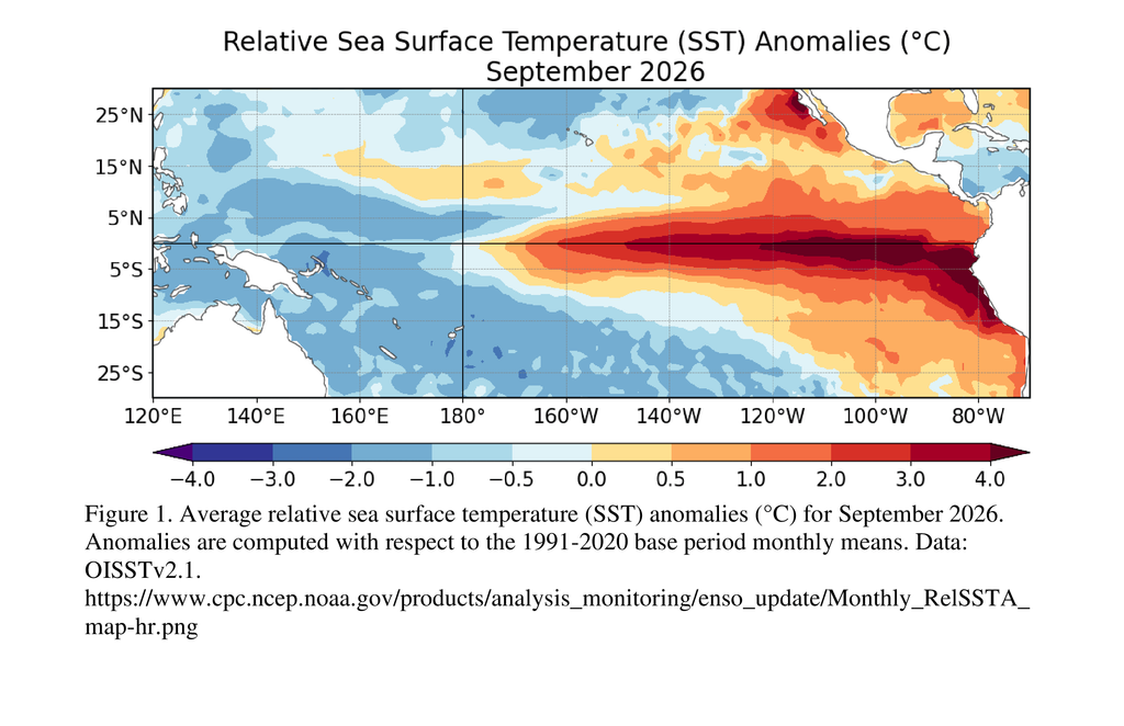
According to NOAA’s latest diagnostic discussion, sea surface temperatures in portions of the eastern equatorial Pacific are now running more than 4 degrees Celsius (7.2 degrees Fahrenheit) above average.
The Niño-3.4 region, one of the primary areas scientists monitor to track El Niño, has warmed to 2.1 degrees Celsius above normal.
Even more remarkable, temperatures beneath the ocean surface in portions of the eastern Pacific are running more than 10 degrees Celsius above average.
Scientists are also observing changes in tropical winds and rainfall patterns consistent with a strengthening El Niño.
In other words, this isn’t simply a patch of unusually warm ocean water. The ocean and atmosphere are responding together, reinforcing the developing event.
Could This Become the Strongest El Niño on Record?
NOAA’s Climate Prediction Center says the odds are increasingly favorable for an exceptionally powerful event.
Its latest outlook assigns the following probabilities of reaching a historic strength threshold of at least +2.5 degrees Celsius using the three-month Relative Oceanic Niño Index (RONI):
| Three-month period | Chance of historic strength |
|---|---|
| September-November 2026 | 54% |
| October-December 2026 | 83% |
| November 2026-January 2027 | 70% |
The Climate Prediction Center also indicates that a strong to very strong El Niño is likely through January-March 2027, with probabilities exceeding 83%.
For perspective, the powerful El Niño events of 1982-83, 1997-98 and 2015-16 are among the most notable in modern history.
NOAA’s current forecast raises the possibility of an event exceeding previous records under its RONI measurement, although that outcome is far from certain.
What Does a Strong El Niño Mean for Wisconsin?
Here’s where things get interesting for those of us living in the Badger State.
El Niño can influence the position and strength of the jet stream, altering the paths storms take across North America.
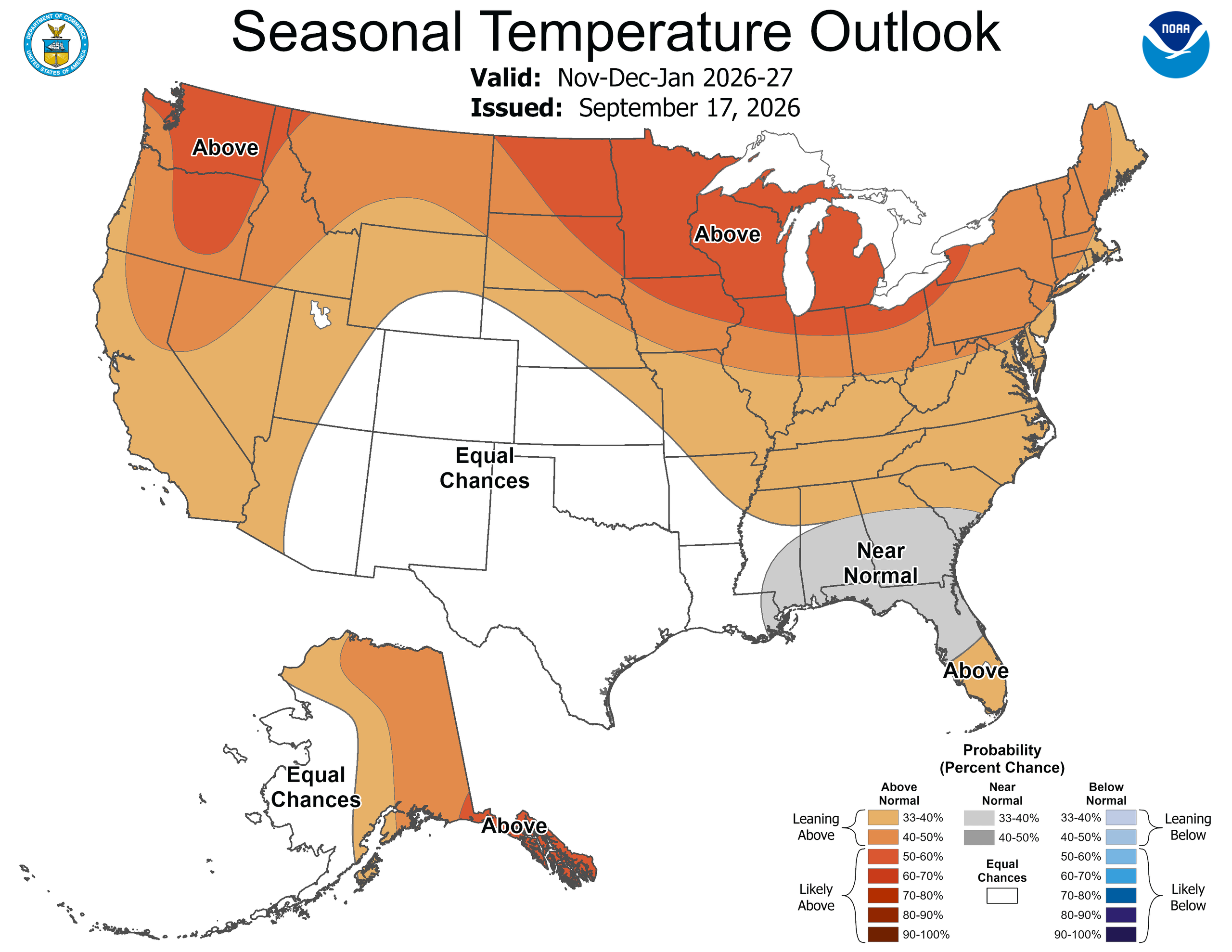
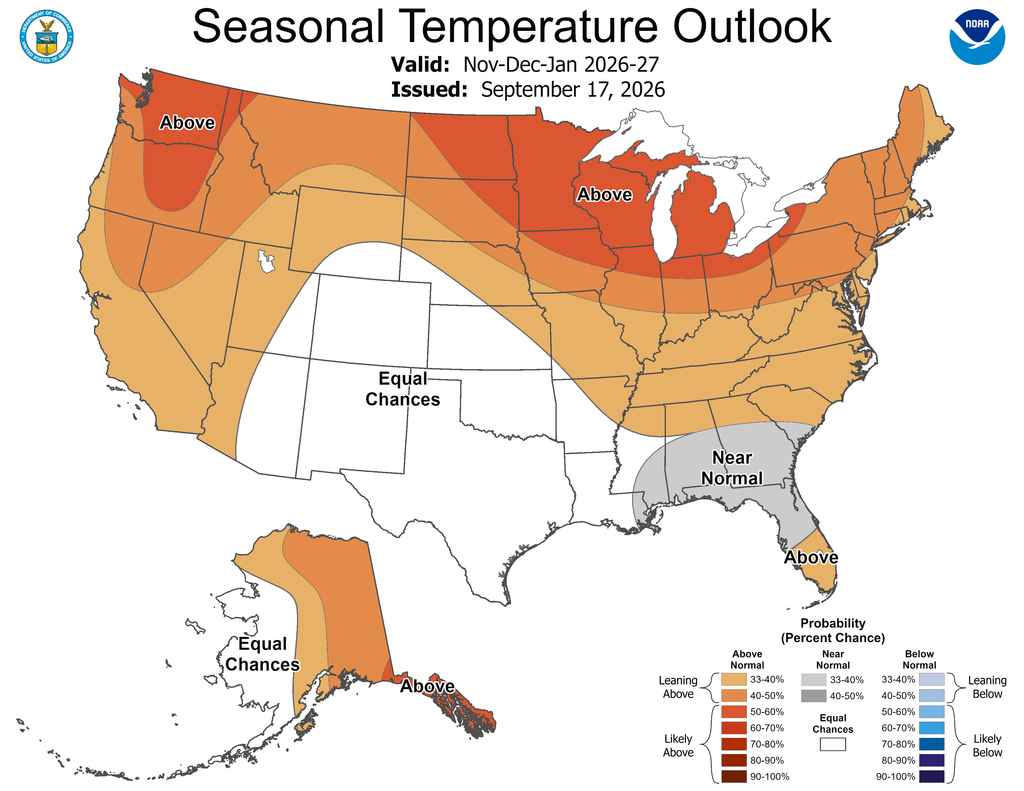
During strong El Niño winters, the northern United States often experiences a greater tendency toward above-normal temperatures, while the southern United States can see a more active storm track.
For Wisconsin, that historically translates into several potential outcomes.
1. A greater chance of a milder winter
Strong El Niño events often favor above-normal winter temperatures across the Upper Midwest. That doesn’t eliminate Arctic outbreaks, but it can reduce the frequency or duration of prolonged cold compared with some other winters.
2. Snowfall becomes a more complicated question
A warmer winter doesn’t automatically mean a snow-free winter.
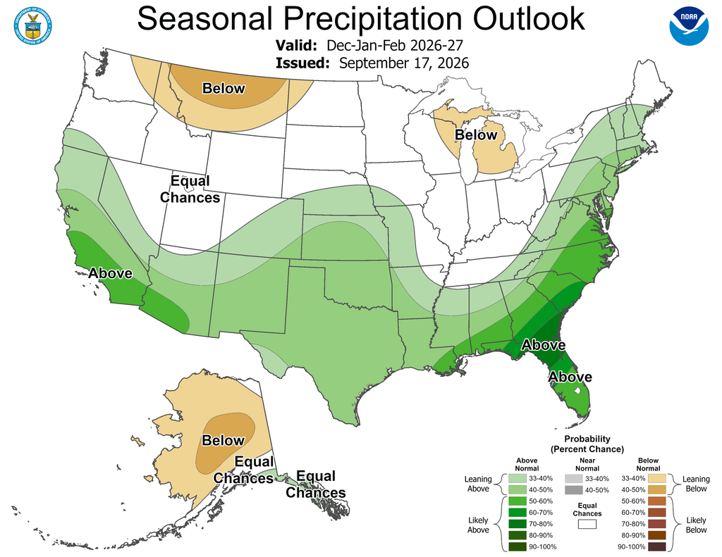
Wisconsin can still experience major snowstorms during El Niño years. Snowfall depends on storm tracks, available moisture and temperatures when individual systems move through the region.
The relationship between El Niño and Wisconsin snowfall is also less consistent than its influence on winter temperatures.
3. Storm tracks could shift
El Niño can strengthen the southern branch of the jet stream, favoring a more active weather pattern across the southern United States.
Depending on how that pattern evolves, some storm systems may track farther south of Wisconsin, potentially affecting the frequency of significant winter precipitation.
However, these are historical tendencies, not guarantees for the upcoming winter.
Why a Historic El Niño Doesn’t Guarantee a Historic Winter
One of the biggest misconceptions about El Niño is that a stronger event automatically produces a more predictable winter.
That’s not necessarily the case.
Other atmospheric patterns, including the Arctic Oscillation and North Atlantic Oscillation, can temporarily override the broader El Niño influence.
A prolonged period of Arctic air, for example, could still bring bitter cold to Wisconsin even during an otherwise mild winter.
And while an exceptionally strong El Niño increases the likelihood of weather patterns associated with the phenomenon, NOAA emphasizes that those impacts are never guaranteed.
The distinction is important: El Niño changes the odds. It doesn’t write the daily forecast.
What’s Next?
NOAA expects El Niño to continue strengthening through the end of 2026, with strong to very strong conditions likely into early 2027.
The next official ENSO Diagnostic Discussion is scheduled for Nov. 12, when scientists will reassess ocean temperatures, atmospheric conditions and the likelihood of a record-setting event.
For Wisconsin, the next several weeks will be particularly important as seasonal forecast guidance begins to better resolve how this unusually powerful Pacific warming event may influence winter temperatures and precipitation.
You can follow the latest developments through NOAA’s Climate Prediction Center and its seasonal climate outlooks.
The Bottom Line: The Pacific Ocean is sending a powerful signal that could tilt the odds toward a milder Wisconsin winter. But before you retire the snowblower or put away the heavy winter coat, remember that even a record-breaking El Niño doesn’t mean Old Man Winter is taking the season off.
Editorial note: The NOAA probabilities and observations come from the Oct. 8 diagnostic discussion provided. The Wisconsin-specific winter implications are historical El Niño tendencies, not a Wisconsin-specific forecast issued in that discussion.
