
A wake low moving through Wisconsin early Tuesday brought sudden strong winds and brief but rapid clearing behind earlier storms.
3 Things to Know
- Strong winds can develop after the rain ends
- Clearing skies and a quick temperature bump often signal arrival
- Impacts may include isolated damage and brief power outages
After Tuesday’s early morning’s storms, the atmosphere wasn’t quite done with us yet. A feature called a wake low developed behind the departing line of thunderstorms, and it packed a punch.
A wake low forms on the backside of a storm system as sinking air warms and pressure drops quickly. That setup creates a tight pressure difference between the cooler, rain-cooled air ahead of it and the warmer air behind it. The result is a burst of strong winds that can arrive suddenly, often after the rain has already moved out.
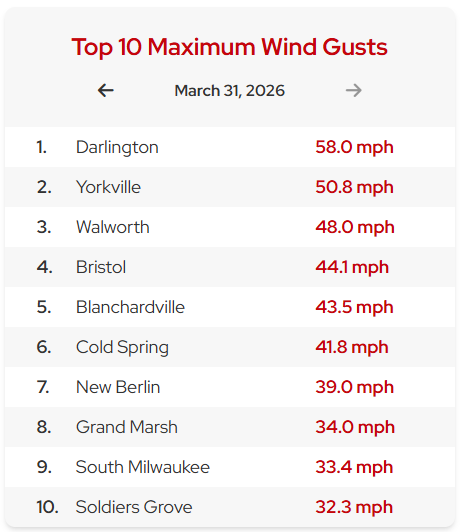
In Southern Wisconsin Tuesday morning many noticed skies clearing, temperatures nudging upward, and then a quick surge of gusty winds. These wind events can be surprisingly strong, sometimes causing tree damage or power outages even without ongoing storms.
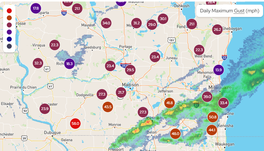
Radar can sometimes show this as a “quiet zone” behind the rain, but the real story is happening at the surface where pressure is falling and winds respond quickly. These setups have become easier to identify thanks to more detailed observation networks and radar velocity data.
The good news is wake lows are typically short-lived. Once the parent storm system fully weakens, the winds ease and conditions settle down.
This is one of those classic “don’t let your guard down” setups. The storms may be leaving, but the atmosphere still has one more move left.