
Severe storms with hail, tornadoes, and damaging winds are possible across Wisconsin and the Great Lakes Tuesday and Wednesday. Updates on our Forecasts Page and our new WWN Live Stream.
3 Things To Know
- Enhanced risk for severe storms Tuesday across southern Wisconsin and the Great Lakes
- Large hail, damaging winds, and tornadoes all possible, especially near the warm front
- Additional storm chances Wednesday with lingering uncertainty on severity
A Volatile Setup Across the Midwest and Great Lakes
An active spring pattern is taking shape across the Midwest and Great Lakes, setting the stage for multiple rounds of severe weather through midweek. A strengthening storm system moving out of the Plains is interacting with warm, humid air surging north into Wisconsin and surrounding states.
The result is a classic severe weather setup with several ingredients aligning, including strong wind shear, increasing instability, and multiple surface boundaries acting as triggers for storm development.
Tuesday: High-Impact Severe Weather Potential
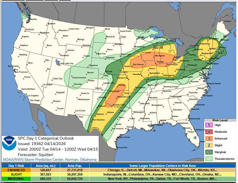
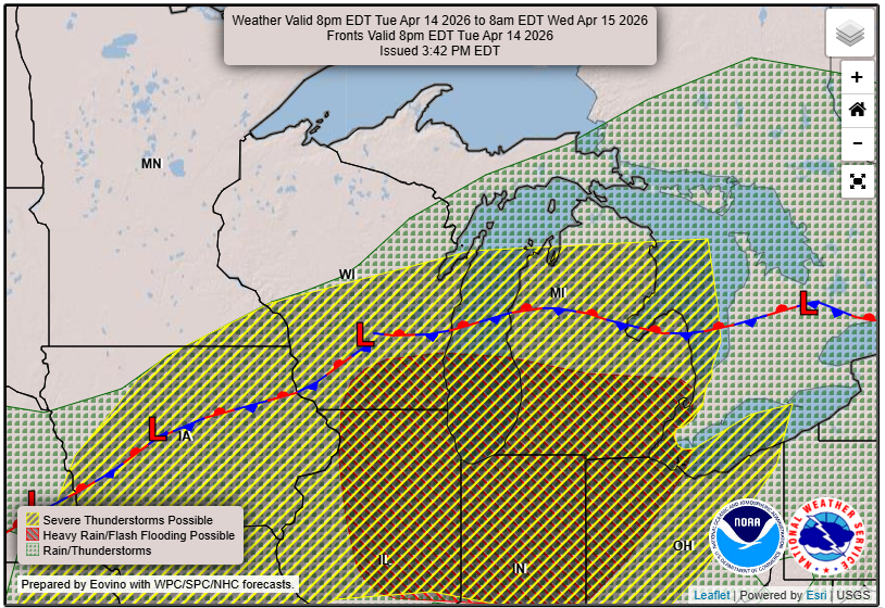
Tuesday afternoon and evening will be the primary window for severe weather across Wisconsin, especially southern and central parts of the state. The Storm Prediction Center has placed much of the region in an enhanced risk, signaling a higher likelihood of organized severe storms.
Storms are expected to develop along a warm front stretching from Iowa into southern Wisconsin and Lower Michigan. This boundary will be a key focus for strong to potentially dangerous storms.
“Severe thunderstorms are expected this afternoon through tonight from the southern Plains into the Midwest. Large to giant hail, several tornadoes (some strong), and swaths of severe damaging gusts are all likely, particularly from Iowa into the southern Great Lakes.”
– NOAA Storm Prediction Center
Any storm that can remain isolated and track along the warm front will have the potential to produce significant severe weather. That includes very large hail, damaging winds, and tornadoes.
“Should a dominant supercell become sustained and discrete for at least a few hours, especially along the warm front over northeast IA into southern WI, a sustained and intense tornado will be possible.”
– NOAA Storm Prediction Center
However, there is still some uncertainty in how storms evolve. If storms quickly merge into clusters or lines, the threat may shift more toward damaging winds and heavy rain rather than long-lived tornado-producing supercells.
Key Threats for Wisconsin Storms
Tornadoes
The greatest tornado risk will be near and just south of the warm front, which is expected to set up somewhere across southern Wisconsin. A few strong tornadoes cannot be ruled out if storms remain discrete.
Large Hail
Conditions are favorable for very large hail, potentially reaching golf ball to baseball size or larger in the most intense storms.
Damaging Winds
As storms grow into clusters during the evening, the threat for widespread damaging wind gusts will increase, especially as activity pushes east into the Great Lakes.
Flooding Concerns
With multiple rounds of storms and the potential for training cells, localized flooding may also become an issue, especially in areas that have already seen recent rainfall.
Wednesday: More Storms, More Questions
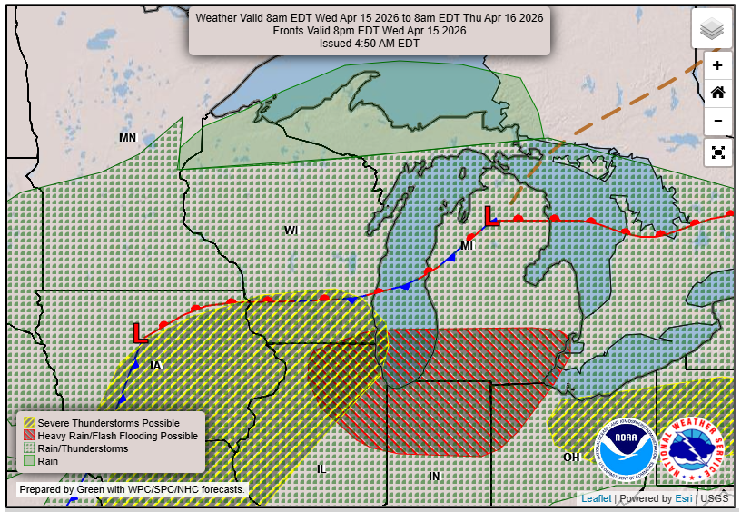
The pattern remains active into Wednesday, but with greater uncertainty. The atmosphere may be worked over from Tuesday’s storms, which could limit instability in some areas. However, if enough recovery occurs, additional strong to severe storms could redevelop.
At this point, Wednesday appears to be a conditional threat day. The exact placement and intensity of storms will depend heavily on how Tuesday’s system evolves.
Bottom Line
Wisconsin and the broader Great Lakes region are entering a multi-day stretch of active weather with a significant severe storm threat Tuesday and at least some risk lingering into Wednesday.
Tuesday is the day to watch closely. The potential is there for all severe hazards, including large hail, damaging winds, and tornadoes. Stay weather aware, have multiple ways to receive warnings, and be ready to act if storms develop in your area.