
MILWAUKEE, Wis. — Forecasters are increasingly concerned that Wisconsin could experience a significant severe weather outbreak Wednesday afternoon through Wednesday night as a powerful storm system moves across the Upper Midwest.
3 Things To Know:
- SEVERE WEATHER THREAT WEDNESDAY: Much of Wisconsin is under an Enhanced Risk (Level 3 of 5) for severe thunderstorms Wednesday afternoon through Wednesday night, with tornadoes, giant hail, and damaging winds all possible.
- TORNADOES AND 75+ MPH WINDS POSSIBLE: Storms may begin as isolated supercells capable of producing large hail and tornadoes before evolving into a line of storms with widespread damaging wind potential during the evening and overnight hours.
- STAY WEATHER AWARE: Exact timing and locations will become clearer over the next 24 hours, but this is one of the more concerning severe weather setups Wisconsin has seen so far this season.
The Storm Prediction Center (SPC) has placed much of Wisconsin under an Enhanced Risk (Level 3 of 5) for severe thunderstorms, indicating that numerous severe storms are possible across the region.
MILWAUKEE, Wis. — Forecasters are increasingly concerned that Wisconsin could experience a significant severe weather outbreak Wednesday afternoon through Wednesday night as a powerful storm system moves across the Upper Midwest.
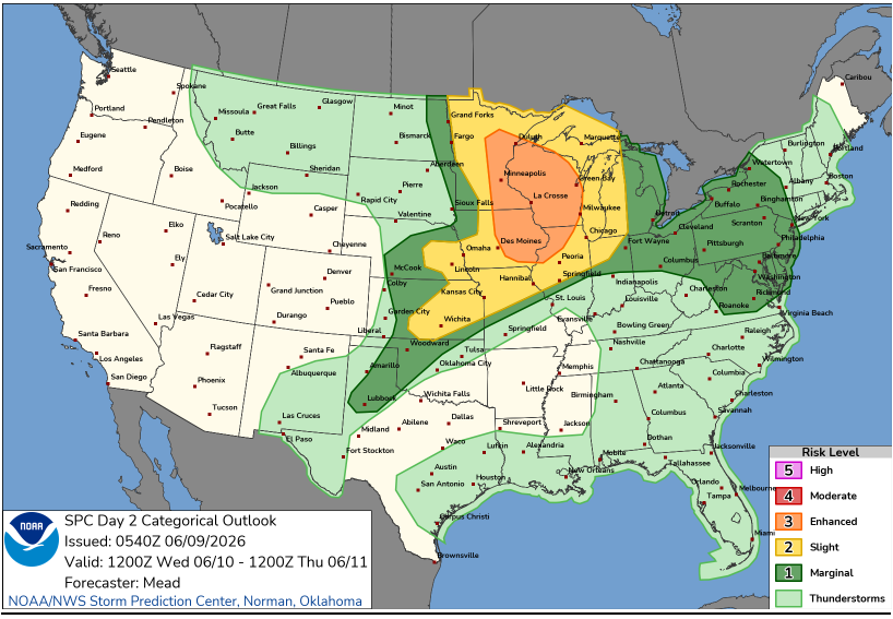
According to the latest outlook, the primary threats include:
- Tornadoes, including the possibility of a few strong tornadoes
- Very large hail, potentially exceeding 2 inches in diameter
- Damaging straight-line winds in excess of 75 mph
- Frequent lightning
- Heavy rainfall and localized flash flooding
Why Forecasters Are Concerned
A strengthening low-pressure system will track across the Northern Plains and Upper Midwest on Wednesday, dragging a cold front eastward toward Wisconsin.
Ahead of the front, warm and humid air will surge northward into the state. Forecast dew points in the upper 60s and lower 70s, combined with strong wind shear throughout the atmosphere, will create an environment favorable for severe thunderstorm development.
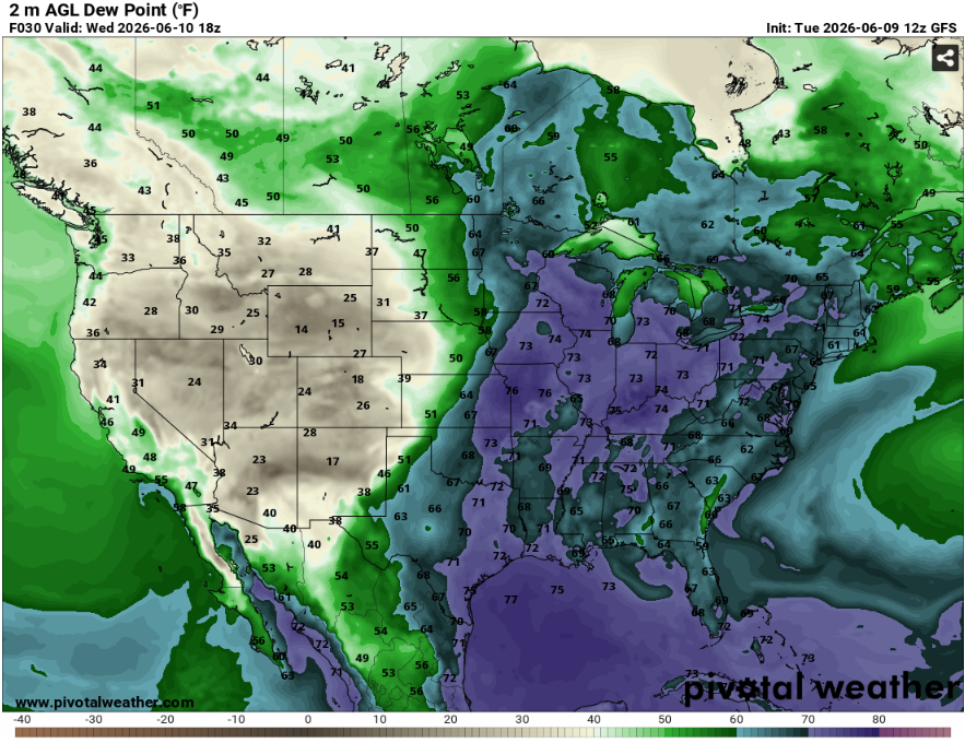
Meteorologists expect storms to initially develop as isolated supercells capable of producing large hail and tornadoes before potentially evolving into a larger line of storms during the evening and overnight hours. If that transition occurs, the threat could shift toward widespread damaging winds while maintaining a continued tornado risk.
Timing Still Being Refined
One factor that could influence the severity and location of the greatest threat will be any thunderstorms that develop Wednesday morning.
Those early-day storms may leave behind outflow boundaries that can act as focal points for additional severe thunderstorm development later in the day. Forecasters will be monitoring these features closely as they often play a key role in determining where the strongest tornadoes develop.
While exact timing and locations remain uncertain, the highest risk period currently appears to be from Wednesday afternoon through Wednesday night.
WWN’s Take
While it is far too early to identify specific counties that may experience the worst conditions, the overall environment forecast for Wednesday contains many of the ingredients typically associated with significant severe weather events in the Upper Midwest.
Residents are encouraged to review severe weather safety plans, ensure they have multiple ways to receive warnings, and stay updated as newer forecast data becomes available.
Wisconsin Weather Now will continue to provide updates as confidence increases in the timing and location of the highest-risk areas.